IMAGES TAKEN NEAR TO
Mill Street, KIDDERMINSTER, DY11 6FB
Introduction
This page details the photographs taken nearby to Mill Street, DY11 6FB by members of the Geograph project.
The Geograph project started in 2005 with the aim of publishing, organising and preserving representative images for every square kilometre of Great Britain, Ireland and the Isle of Man.

There are currently over 7.5m images from over14,400 individuals and you can help contribute to the project by visiting https://www.geograph.org.uk
Image Map
Images are licensed for reuse under creativecommons.org/licenses/by-sa/2.0
Notes
- Clicking on the map will re-center to the selected point.
- The higher the marker number, the further away the image location is from the centre of the postcode.
Image Listing (387 Images Found)
Images are licensed for reuse under creativecommons.org/licenses/by-sa/2.0
Image
Details
Distance
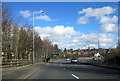
1
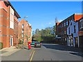
Mill Street, Kidderminster
A lot of the buildings at this end of Mill Street are relatively recent. The post box dates from the reign of King George VI. See:- Image
Image: © P L Chadwick
Taken: 23 Apr 2013
0.02 miles
2
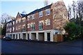
Modern apartment block, Mill Street, Kidderminster, Worcs
This block of residential apartments was built in the last few years.
Image: © P L Chadwick
Taken: 1 Dec 2019
0.02 miles
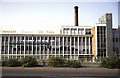
3
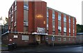
Margaret Thatcher House, 35 Mill Street, Kidderminster, Worcs
This office block was named after the UK's first female Prime Minister, who was the Conservative Prime Minster for the period 1979-1990. Part of the building is used by the local Wyre Forest Conservative Association.
Image: © P L Chadwick
Taken: 1 Dec 2019
0.02 miles
4
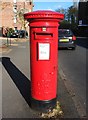
King George VI post box, Mill Street, Kidderminster
This post box dates from the reign of King George VI (1936-1952). It can also be seen in this view of Mill Street, which is in the town's business area:- Image
Post box number:- DY11 19. Post code:- DY11 6**. Last collection:- 5.15 p.m. Monday to Friday; 11.45 a.m. Saturday.
Image: © P L Chadwick
Taken: 23 Apr 2013
0.03 miles
5
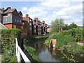
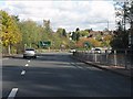
River Stour flowing behind properties in Mill Street
Image: © John M
Taken: 18 May 2008
0.03 miles
6
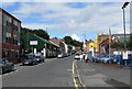
Looking up Mill Street in Kidderminster
Image: © Mat Fascione
Taken: 14 Jul 2007
0.04 miles
8
Carpet Factory, Kidderminster
According to Colin Bowden and the book "Woven in Kidderminster" by M Thompson this was built in 1962 for Carpet Trades Ltd and replaced an earlier building. This became Gilt Edge Carpets in 1967 and it appears Crossley & Kosset were also later involved. It was apparently demolished within 30 years of its construction.
Image: © Chris Allen
Taken: 16 Aug 1987
0.05 miles
10
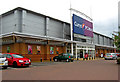
Currys & P C World, Carpet Trades Way, Crossley Retail Park, Kidderminster
Currys & P C World are part of the same group. They used to have separate stores on this retail park. In May 2011 the two stores were merged into what is described as a two-in-one superstore, on the site previously occupied by Currys. The upstairs floor is occupied by white goods and other electrical items sold by Currys, but the ground floor is devoted to computer items, and audio and video, including TV's and cameras. The old PC World store has been closed. It seems this merger process is likely to be carried out across the country, presumably leaving a trail of yet more empty shop units.
Image: © P L Chadwick
Taken: 21 May 2011
0.05 miles