IMAGES TAKEN NEAR TO
Mason Road, KIDDERMINSTER, DY11 6AE
Introduction
This page details the photographs taken nearby to Mason Road, DY11 6AE by members of the Geograph project.
The Geograph project started in 2005 with the aim of publishing, organising and preserving representative images for every square kilometre of Great Britain, Ireland and the Isle of Man.

There are currently over 7.5m images from over14,400 individuals and you can help contribute to the project by visiting https://www.geograph.org.uk
Image Map (Loading...)


Getting Data...Please wait
Leaflet Map data © OpenStreetMap
Images are licensed for reuse under creativecommons.org/licenses/by-sa/2.0
Notes
- Clicking on the map will re-center to the selected point.
- The higher the marker number, the further away the image location is from the centre of the postcode.
Image Listing (74 Images Found)
Images are licensed for reuse under creativecommons.org/licenses/by-sa/2.0
Image
Details
Distance
1
Kidderminster roundabout
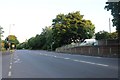
Franche Road, Marlpool Lane, Puxton Lane, Proud Cross Ringway and Mason road all meet here.
Image: © Mat Fascione
Taken: 14 Jul 2007
0.01 miles
3
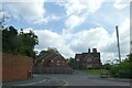
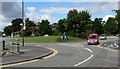
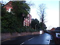
Roundabout on A442 at north of Blakebrook
Marked on an old map as "Proud Cross" and the building ahead as "Infirmary"
Image: © David Smith
Taken: 12 May 2023
0.03 miles
4
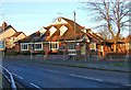
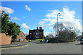
Jacksons, Marlpool Lane, Kidderminster
This large pub is on the corner of Franche Road and Marlpool Lane. The entrance to the car park is from Marlpool Lane. This view is from near where Franche Road joins the roundabout.
Another view:- Image
Update (October 2011):- the pub closed earlier this year, and the building is now used by a SPAR convenience store. See:- Image
Image: © P L Chadwick
Taken: 3 Jan 2009
0.04 miles
5
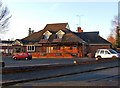
Jacksons, Marlpool Lane, Kidderminster
This large pub has frontages to both Marlpool Lane and Franche Road. This view is from Marlpool Lane.
Another view:- Image
Update (October 2011):- the pub closed earlier this year, and the building is now used by a SPAR conveniencec store. See:- Image
Image: © P L Chadwick
Taken: 3 Jan 2009
0.04 miles
8
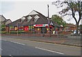
SPAR store (formerly Jacksons), 246 Marlpool Lane, Kidderminster
Another Kidderminster pub has bitten the dust with the closure of Jacksons, a Marston's house, which was operating here at least up to June 2011. The building is now used by a new SPAR convenience store, which seems to be doing a good trade. This probably couldn't be said of the pub, which often had one or two dodgy looking characters hanging about outside, but probably that is being unkind, and they were just people having a quick cigarette.
The store has frontages to both Franche Road (part of the A442), and Marlpool Lane. This photo shows the Franche Road frontage.
Two views of the former pub:- Image, and Image
Image: © P L Chadwick
Taken: 9 Oct 2011
0.06 miles