IMAGES TAKEN NEAR TO
Kinver Lane, KIDDERMINSTER, DY11 5YU
Introduction
This page details the photographs taken nearby to Kinver Lane, DY11 5YU by members of the Geograph project.
The Geograph project started in 2005 with the aim of publishing, organising and preserving representative images for every square kilometre of Great Britain, Ireland and the Isle of Man.

There are currently over 7.5m images from over14,400 individuals and you can help contribute to the project by visiting https://www.geograph.org.uk
Image Map (Loading...)


Getting Data...Please wait
Leaflet Map data © OpenStreetMap
Images are licensed for reuse under creativecommons.org/licenses/by-sa/2.0
Notes
- Clicking on the map will re-center to the selected point.
- The higher the marker number, the further away the image location is from the centre of the postcode.
Image Listing (1 Images Found)
Images are licensed for reuse under creativecommons.org/licenses/by-sa/2.0
Image
Details
Distance
1
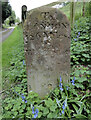
Old Milestone, Now Caunsall, near Cookley
The milestone was originally on the B4203 at Stanford on Terne (ST 6967 6537) and is now in a driveway at Caunsall. Parish of Stanford with Orleton (Malvern Hills District). Metal plate attached to stone post, Hundred House stone design, originally erected by the Hundred House (First District) turnpike trust in the 19th century.
The inscription on the opposite face reads:-
{right pointing hand} / BROMYARD / 7½ MILES / {left pointing hand} / WORCESTER / 14
Inscription on this face reads:-
To / LONDON / 126 Miles / To / WORCESTER / 14 /To / TENBURY /8
Milestone Society National ID: WO_BYSP08
Image: © Roadside Relics
Taken: 23 Apr 2024
0.17 miles