IMAGES TAKEN NEAR TO
Franche Road, KIDDERMINSTER, DY11 5AQ
Introduction
This page details the photographs taken nearby to Franche Road, DY11 5AQ by members of the Geograph project.
The Geograph project started in 2005 with the aim of publishing, organising and preserving representative images for every square kilometre of Great Britain, Ireland and the Isle of Man.

There are currently over 7.5m images from over14,400 individuals and you can help contribute to the project by visiting https://www.geograph.org.uk
Image Map (Loading...)


Getting Data...Please wait
Leaflet Map data © OpenStreetMap
Images are licensed for reuse under creativecommons.org/licenses/by-sa/2.0
Notes
- Clicking on the map will re-center to the selected point.
- The higher the marker number, the further away the image location is from the centre of the postcode.
Image Listing (39 Images Found)
Images are licensed for reuse under creativecommons.org/licenses/by-sa/2.0
Image
Details
Distance
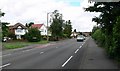
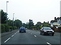
4
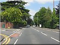
Franche Road (A442) at Broomfield Road
Image: © Peter Whatley
Taken: 8 Jun 2013
0.08 miles
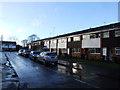
8
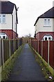
Start of footpath from Franche Road, Kidderminster
This long public footpath eventually comes out on Wilton Avenue, but it can also be used to access White Wickets Park, a public park.
Image
Image: © P L Chadwick
Taken: 28 Feb 2015
0.14 miles
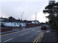
9
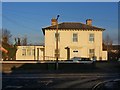
Burgage Lodge, 184 Franche Road, Kidderminster
This large attractive detached villa is now used as offices.
Image: © P L Chadwick
Taken: 3 Jan 2009
0.14 miles