IMAGES TAKEN NEAR TO
Dotterel Place, KIDDERMINSTER, DY10 4UD
Introduction
This page details the photographs taken nearby to Dotterel Place, DY10 4UD by members of the Geograph project.
The Geograph project started in 2005 with the aim of publishing, organising and preserving representative images for every square kilometre of Great Britain, Ireland and the Isle of Man.

There are currently over 7.5m images from over14,400 individuals and you can help contribute to the project by visiting https://www.geograph.org.uk
Image Map (Loading...)


Getting Data...Please wait
Leaflet Map data © OpenStreetMap
Images are licensed for reuse under creativecommons.org/licenses/by-sa/2.0
Notes
- Clicking on the map will re-center to the selected point.
- The higher the marker number, the further away the image location is from the centre of the postcode.
Image Listing (30 Images Found)
Images are licensed for reuse under creativecommons.org/licenses/by-sa/2.0
Image
Details
Distance
1
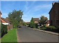
Turnstone Road, Spennells, Kidderminster
A residential road in suburban Kidderminster.
Image: © P L Chadwick
Taken: 6 Oct 2013
0.06 miles
2
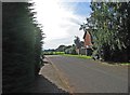
Approaching the end of Turnstone Road, Spennells, Kidderminster
Turnstone Road is a long residential road off Captain's Pool Road. There are many more residential roads off Turnstone Road. Here it terminates by a field, to which there is access.
Image: © P L Chadwick
Taken: 6 Oct 2013
0.07 miles
3
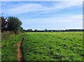
Field and bridleway, Spennells, Kidderminster
On the OS map the bridleway, seen on the left, is marked as part of a circular path called Railway Path.
Image: © P L Chadwick
Taken: 6 Oct 2013
0.09 miles
4
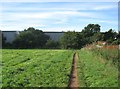
Corner of a field and bridleway, Spennells, Kidderminster
Behind the hedge is the Kidderminster - Worcester railway line. Behind that are some industrial units which are quite recent. In the foreground is a bridlepath, which forms part of a circular path called Railway Path on the OS map. At the corner the path goes left but the bridleway turns right and runs adjacent to the railway line for some distance.
Image: © P L Chadwick
Taken: 6 Oct 2013
0.10 miles
5
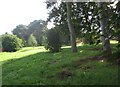
Open space adjacent to Captain's Pool Road, Spennells, Kidderminster
A pleasant green area adjacent to Captain's Pool Road. There is a footpath through it.
Image: © P L Chadwick
Taken: 6 Oct 2013
0.11 miles
6

Electricity sub-station, Captain's Pool Road, Spennells, Kidderminster
Located near the junction with Turnstone Road.
Image: © P L Chadwick
Taken: 6 Oct 2013
0.11 miles
7
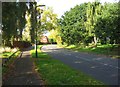
Captain's Pool Road, Spennells, Kidderminster
On this stretch of the road there is some public open space land on both sides.
Image: © P L Chadwick
Taken: 6 Oct 2013
0.11 miles
8
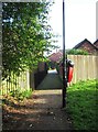
Footpath from Captain's Pool Road to Yellowhammer Court, Spennells, Kidderminster
Looking towards Yellowhammer Court. The red bin is for dog waste.
Image: © P L Chadwick
Taken: 6 Oct 2013
0.12 miles
10
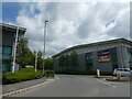
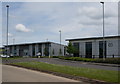
Self-storage building off A449, Hoobrook
Image: © David Smith
Taken: 12 May 2023
0.14 miles