IMAGES TAKEN NEAR TO
Lodge Ford Hill, KIDDERMINSTER, DY10 4QS
Introduction
This page details the photographs taken nearby to Lodge Ford Hill, DY10 4QS by members of the Geograph project.
The Geograph project started in 2005 with the aim of publishing, organising and preserving representative images for every square kilometre of Great Britain, Ireland and the Isle of Man.

There are currently over 7.5m images from over14,400 individuals and you can help contribute to the project by visiting https://www.geograph.org.uk
Image Map
Images are licensed for reuse under creativecommons.org/licenses/by-sa/2.0
Notes
- Clicking on the map will re-center to the selected point.
- The higher the marker number, the further away the image location is from the centre of the postcode.
Image Listing (9 Images Found)
Images are licensed for reuse under creativecommons.org/licenses/by-sa/2.0
Image
Details
Distance
1
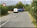
Clattercut Lane junction with A448
Looking along Clattercut Lane to its junction with A448 Bromsgrove to Kidderminster road. And no, the two vehicles have NOT had a coming together!
Image: © Mike Dodman
Taken: 29 Aug 2024
0.02 miles
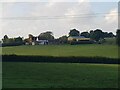
4
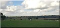
Cows by footpath near Tagg Farm, Chaddesley Corbett
Image: © Jeff Gogarty
Taken: 13 Oct 2022
0.16 miles
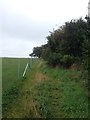
5
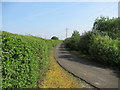
Lane to Tag Farm, where the footpath crosses it
Image: © Jeff Gogarty
Taken: 30 Apr 2019
0.17 miles
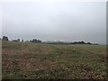
6
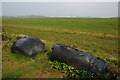
Farmland to the east of Chaddesley Corbett
In the foreground two old silage bales block the entrance to the field.
Image: © Philip Halling
Taken: 31 Mar 2007
0.21 miles
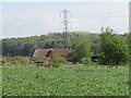
8
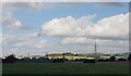
Power lines across the landscape near Tagg Farm
Image: © Jeff Gogarty
Taken: 13 Oct 2022
0.24 miles