IMAGES TAKEN NEAR TO
Wolverley Road, KIDDERMINSTER, DY10 3QB
Introduction
This page details the photographs taken nearby to Wolverley Road, DY10 3QB by members of the Geograph project.
The Geograph project started in 2005 with the aim of publishing, organising and preserving representative images for every square kilometre of Great Britain, Ireland and the Isle of Man.

There are currently over 7.5m images from over14,400 individuals and you can help contribute to the project by visiting https://www.geograph.org.uk
Image Map (Loading...)


Getting Data...Please wait
Leaflet Map data © OpenStreetMap
Images are licensed for reuse under creativecommons.org/licenses/by-sa/2.0
Notes
- Clicking on the map will re-center to the selected point.
- The higher the marker number, the further away the image location is from the centre of the postcode.
Image Listing (3 Images Found)
Images are licensed for reuse under creativecommons.org/licenses/by-sa/2.0
Image
Details
Distance
1
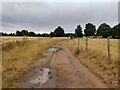
Public bridleway at Lea Castle
This bridleway and track is on the site of the former Lea Castle country estate. Lea Castle was a Grade II listed Neo Gothic mock castle mansion, it was built by Edward Knight in 1762, by 1939 it was dilapidated. Lea Castle was demolished in 1945.
Image: © Mat Fascione
Taken: 23 Jul 2022
0.08 miles
2
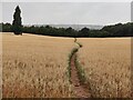
Path across farmland towards Wolverley
This path and farmland is on the site of the former Lea Castle country estate. Lea Castle was a Grade II listed Neo Gothic mock castle mansion, it was built by Edward Knight in 1762, by 1939 it was dilapidated. Lea Castle was demolished in 1945.
Image: © Mat Fascione
Taken: 23 Jul 2022
0.11 miles
3
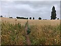
Path across farmland
This path and farmland is on the site of the former Lea Castle country estate. Lea Castle was a Grade II listed Neo Gothic mock castle mansion, it was built by Edward Knight in 1762, by 1939 it was dilapidated. Lea Castle was demolished in 1945.
Image: © Mat Fascione
Taken: 23 Jul 2022
0.22 miles