IMAGES TAKEN NEAR TO
Sugar Loaf Lane, KIDDERMINSTER, DY10 3PA
Introduction
This page details the photographs taken nearby to Sugar Loaf Lane, DY10 3PA by members of the Geograph project.
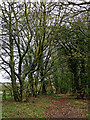
The Geograph project started in 2005 with the aim of publishing, organising and preserving representative images for every square kilometre of Great Britain, Ireland and the Isle of Man.

There are currently over 7.5m images from over14,400 individuals and you can help contribute to the project by visiting https://www.geograph.org.uk
Image Map
Images are licensed for reuse under creativecommons.org/licenses/by-sa/2.0
Notes
- Clicking on the map will re-center to the selected point.
- The higher the marker number, the further away the image location is from the centre of the postcode.
Image Listing (35 Images Found)
Images are licensed for reuse under creativecommons.org/licenses/by-sa/2.0
Image
Details
Distance
2
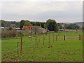
Pasture near Iverley in Staffordshire
These paddocks are by the Highdown Nuresery, off Sugar Loaf Lane.
Image: © Roger Kidd
Taken: 31 Oct 2018
0.10 miles
3
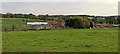
Pasture near Iverley in Worcestershire
Pastures and paddocks are seen here near Highdown Nursery (off Sugar Loaf Lane). Occasional black splodges are a flock of mobile crows.
Image: © Roger Kidd
Taken: 31 Oct 2018
0.14 miles
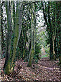
4
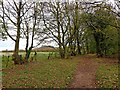
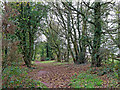
Bridleway towards Iverley in Staffordshire
Leading eastwards here, the North Worcestershire Path passes along a bridleway more like a green lane between fields as far as Sugar Loaf Lane.
https://en.wikipedia.org/wiki/North_Worcestershire_Path
P L Chadwick observed in 2015:
Image: © Roger Kidd
Taken: 31 Oct 2018
0.16 miles
5
North Worcestershire Path near Iverley in Staffordshire
Leading eastwards here, the North Worcestershire Path passes along a bridleway more like a green lane between fields as far as Sugar Loaf Lane.
https://en.wikipedia.org/wiki/North_Worcestershire_Path
Image: © Roger Kidd
Taken: 31 Oct 2018
0.16 miles
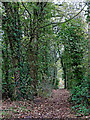
6
Bridleway near Iverley in Staffordshire
Leading eastwards here, the North Worcestershire Path passes along a bridleway more like a green lane between fields as far as Sugar Loaf Lane.
https://en.wikipedia.org/wiki/North_Worcestershire_Path
Image: © Roger Kidd
Taken: 31 Oct 2018
0.16 miles
7
North Worcestershire Path near Iverley in Staffordshire
Leading eastwards here, the North Worcestershire Path passes along a bridleway more like a green lane between fields as far as Sugar Loaf Lane.
Image: © Roger Kidd
Taken: 31 Oct 2018
0.16 miles
8
North Worcestershire Path near Iverley in Staffordshire
Leading eastwards here, the North Worcestershire Path passes along a bridleway more like a green lane between fields as far as Sugar Loaf Lane.
https://en.wikipedia.org/wiki/North_Worcestershire_Path
Image: © Roger Kidd
Taken: 31 Oct 2018
0.17 miles
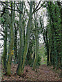
9
Bridleway west of Iverley in Staffordshire
Leading westwards here, the North Worcestershire Path passes along a bridleway more like a green lane between fields. The bridleway leads to Beechtree Lane, but the footpath continues through the woodland area by the Fairy Glen, across fields towards Caunsall and Kinver.
https://en.wikipedia.org/wiki/North_Worcestershire_Path
Image: © Roger Kidd
Taken: 31 Oct 2018
0.17 miles
10
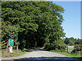
Sugar Loaf Lane near Churchill in Worcestershire
Looking north-north-east from near Iverley House Farm. The lane passes through Iverley and past Sugar Loaf Farm (about a mile away), then leads on towards Stourbridge.
Image: © Roger Kidd
Taken: 9 Sep 2020
0.18 miles