IMAGES TAKEN NEAR TO
Sion Hill, KIDDERMINSTER, DY10 2YY
Introduction
This page details the photographs taken nearby to Sion Hill, DY10 2YY by members of the Geograph project.
The Geograph project started in 2005 with the aim of publishing, organising and preserving representative images for every square kilometre of Great Britain, Ireland and the Isle of Man.

There are currently over 7.5m images from over14,400 individuals and you can help contribute to the project by visiting https://www.geograph.org.uk
Image Map (Loading...)


Getting Data...Please wait
Leaflet Map data © OpenStreetMap
Images are licensed for reuse under creativecommons.org/licenses/by-sa/2.0
Notes
- Clicking on the map will re-center to the selected point.
- The higher the marker number, the further away the image location is from the centre of the postcode.
Image Listing (16 Images Found)
Images are licensed for reuse under creativecommons.org/licenses/by-sa/2.0
Image
Details
Distance
2
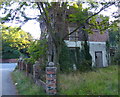
Derelict South Lodge along Wolverley Road
This derelict lodge is one of the two South Lodges along Wolverley Road, the other lodge is converted into a house. The lodges were once part of the imposing Lea Castle country estate. Lea Castle was built with the profits of the local iron industry. Edward Knight owned two local iron mills, he had Lea Castle built in the neo-Gothic style in 1762. Lea Castle was eventually demolished in 1945. All that remains of the house is some parkland and the long boundary wall, along with the South and North lodges.
Image: © Mat Fascione
Taken: 9 Sep 2020
0.16 miles
3
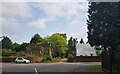
Junction of Sion Hill and Wolverley Road
Showing both South Lodge buildings. The left one still appears derelict Image
Image: © Jeff Gogarty
Taken: 13 Jul 2023
0.17 miles
4
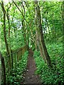
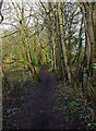
Public footpath through wood
This narrow public footpath has railings on the left in this section.
Image: © P L Chadwick
Taken: 22 May 2009
0.17 miles
5
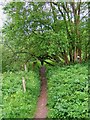
Public footpath through wood
This public footpath which connects, in the other direction, with the nearby Springfield Park, here passes through a wood.
Image: © P L Chadwick
Taken: 22 May 2009
0.18 miles
6
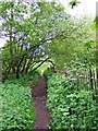
Public footpath through wood
The iron railings on the right are in a very poor state; in places they have completely fallen over. On the left of the path can be seen some brickwork. There are other traces along the path too, so clearly there was a wall and/or a building adjacent to it years ago.
Image: © P L Chadwick
Taken: 22 May 2009
0.18 miles
7
Footpath branching off public footpath to B4189, near Kidderminster, Worcs
This footpath does not appear to be a public one but it seems to be fairly well used. It branches off a public footpath which links Springfield Park to the B4189 road, near Wolverley.
Image: © P L Chadwick
Taken: 15 Jan 2023
0.19 miles
8
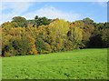
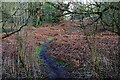
Trees at edge of field, Springfield Park, Kidderminster
It's never been quite clear whether this field is actually in the park or not, but to all intents and purposes it seems to be, as there is a public footpath across it and people, with or without their dogs, wander all over it.
Image: © P L Chadwick
Taken: 13 Nov 2013
0.19 miles
9
Public footpath to B4189 road, near Wolverley, Worcs
The footpath runs between Springfield Park, Kidderminster, and the B4189 road near Wolverley.
Image: © P L Chadwick
Taken: 15 Jan 2023
0.19 miles