IMAGES TAKEN NEAR TO
Batham Road, KIDDERMINSTER, DY10 2TN
Introduction
This page details the photographs taken nearby to Batham Road, DY10 2TN by members of the Geograph project.
The Geograph project started in 2005 with the aim of publishing, organising and preserving representative images for every square kilometre of Great Britain, Ireland and the Isle of Man.

There are currently over 7.5m images from over14,400 individuals and you can help contribute to the project by visiting https://www.geograph.org.uk
Image Map
Images are licensed for reuse under creativecommons.org/licenses/by-sa/2.0
Notes
- Clicking on the map will re-center to the selected point.
- The higher the marker number, the further away the image location is from the centre of the postcode.
Image Listing (79 Images Found)
Images are licensed for reuse under creativecommons.org/licenses/by-sa/2.0
Image
Details
Distance
3
Waterwheel, Broadwaters Mill, Broadwaters Park
This waterwheel has recently been placed here. The Mill is in Broadwaters Park, part of which is adjacent to Stourbridge Road, Kidderminster.
Image: © P L Chadwick
Taken: 18 May 2008
0.14 miles
4
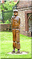
Sculpture of a man, Broadwaters Park
This sculpture has been placed in Broadwaters Park next to Broadwaters Mill.
Image: © P L Chadwick
Taken: 18 May 2008
0.14 miles
5
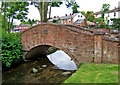
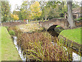
Footbridge, Broadwaters Park
This footbridge in Broadwaters Park is near Broadwaters Mill and takes the park's main footpath across the mill stream.
Image: © P L Chadwick
Taken: 18 May 2008
0.14 miles
6
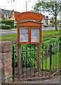
Friends of Broadwaters Noticeboard, Broadwaters Park
Broadwaters Park, adjacent to Stourbridge Road Kidderminster, is managed by Wyre Forest District Council with the assistance of volunteers from The Friends of Broadwaters. This group have helped with the park's development as well as with ongoing maintenance by attracting funding and providing volunteer work. This is the group's noticeboard in the park near Broadwaters Mill.
http://www.wyreforestdc.gov.uk/ccm/navigation/planning-environment/parks-and-green-spaces/?page=4
Image: © P L Chadwick
Taken: 18 May 2008
0.14 miles
7
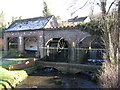
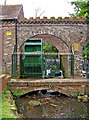
Broadwaters Mill, Kidderminster, Worcs
The mill is also known as Upton Mill. The watermill had a varied history as a corn mill, in the cloth trade, as an iron forge and as a laundry.
Image: © Richard Rogerson
Taken: 20 Feb 2010
0.14 miles
8
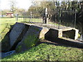
The sluice gate, Broadwaters Mill, Kidderminster, Worcs
Image: © Richard Rogerson
Taken: 20 Feb 2010
0.14 miles
10
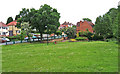
Broadwaters Park, Stourbridge Road
This is the far end of Broadwaters Park Kidderminster, with Stourbridge Road in the distance. The view is looking in the Stourbridge direction. In the far distance, beyond the red dog waste bin, at the end of the green painted metal fence is an arch which is the formal entrance to the park from this end of Stourbridge Road.
http://www.wyreforestdc.gov.uk/ccm/navigation/planning-environment/parks-and-green-spaces/?page=4
Image: © P L Chadwick
Taken: 18 May 2008
0.14 miles