IMAGES TAKEN NEAR TO
Chester Road North, KIDDERMINSTER, DY10 2RZ
Introduction
This page details the photographs taken nearby to Chester Road North, DY10 2RZ by members of the Geograph project.
The Geograph project started in 2005 with the aim of publishing, organising and preserving representative images for every square kilometre of Great Britain, Ireland and the Isle of Man.

There are currently over 7.5m images from over14,400 individuals and you can help contribute to the project by visiting https://www.geograph.org.uk
Image Map (Loading...)


Getting Data...Please wait
Leaflet Map data © OpenStreetMap
Images are licensed for reuse under creativecommons.org/licenses/by-sa/2.0
Notes
- Clicking on the map will re-center to the selected point.
- The higher the marker number, the further away the image location is from the centre of the postcode.
Image Listing (99 Images Found)
Images are licensed for reuse under creativecommons.org/licenses/by-sa/2.0
Image
Details
Distance
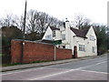
1
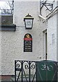
The Yew Tree (detail), Chester Road North
Entering this pub by the gate from Chester Road North, there is an exterior light in an attractive lantern. This has the Banks's Brewery lion on it. Below is a sign with the pub opening hours, which are mainly in the evening, which is probably another sign of the difficult times facing pubs at present. It also states there is a lounge/bar, pub games and a beer garden. Finally at the bottom it states "Unspoilt by progress". Image Image
Image: © P L Chadwick
Taken: 1 Jan 2009
0.03 miles
2
The Yew Tree, Chester Road North
Sometimes known as The Yew Tree Inn, though on the building and the pub sign there is no mention of the word "inn". The car park is behind where the Banks's Brewery sign is.
Update April 2015 - It has recently closed. It seems a housing development is planned.
Image: © P L Chadwick
Taken: 1 Jan 2009
0.03 miles
3
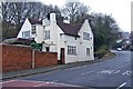
The Yew Tree, Chester Road North
This pub with car park is on the busy Chester Road North which is part of the A449. The pub is sometimes referred to as The Yew Tree Inn.
Update April 2015 - It has recently closed. It seems a housing development is planned.
Image: © P L Chadwick
Taken: 1 Jan 2009
0.03 miles
4
The Rose Theatre, Chester Road North
Kidderminster's own theatre opened in 1981 to replaced the demolished Playhouse. Named after Kenneth Rose, who was Chairman of the Nonentities, the amateur theatrical group which owned The Playhouse, and now administer The Rose Theatre. Sadly Mr. Rose died before the new theatre was built. Image
Image: © P L Chadwick
Taken: 1 Jan 2009
0.03 miles
5
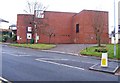
The Rose Theatre, Chester Road North
Building commenced in 1980 and the theatre opened in 1981. It was built because Kidderminster's previous theatre, The Playhouse, an Edwardian structure, was demolished so the Ring Road could be built. The Rose Theatre was partially funded out of the compensation money received in respect of that. The Rose Theatre puts on both amateur and professional performances. It is administered by a charitable trust.
Externally the building looks functional rather than attractive. It is quite sizeable so it is perhaps rather surprising that the main theatre only seats 181 people, and the Studio seats 60. It does of course have to compete with nearby theatres in Birmingham, Malvern & Wolverhampton so one must be grateful that The Rose Theatre exists at all.
Image: © P L Chadwick
Taken: 1 Jan 2009
0.03 miles
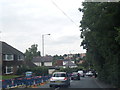
7
Path to Springfield Park from Chester Road
The path leads to the public park known as Springfield Park. Image
Image: © P L Chadwick
Taken: 23 Dec 2009
0.05 miles
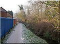
9
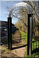
Arched entrance to Springfield Park
Entrance to Springfield Park and footpath which follows the back of a stream, a tributary of the River Stour.
Image: © Philip Halling
Taken: 5 Apr 2018
0.07 miles
10
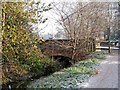
Broadwaters Bridge
The footpath from Springfield Park ends here at Broadwaters Bridge (seen on the left), which carries the A449 road across the stream, which runs alongside the path. The bridge was built in 1937 by Worcestershire County Council. Image
Image: © P L Chadwick
Taken: 23 Dec 2009
0.07 miles