IMAGES TAKEN NEAR TO
Westcott Road, KIDDERMINSTER, DY10 2GE
Introduction
This page details the photographs taken nearby to Westcott Road, DY10 2GE by members of the Geograph project.
The Geograph project started in 2005 with the aim of publishing, organising and preserving representative images for every square kilometre of Great Britain, Ireland and the Isle of Man.

There are currently over 7.5m images from over14,400 individuals and you can help contribute to the project by visiting https://www.geograph.org.uk
Image Map (Loading...)


Getting Data...Please wait
Leaflet Map data © OpenStreetMap
Images are licensed for reuse under creativecommons.org/licenses/by-sa/2.0
Notes
- Clicking on the map will re-center to the selected point.
- The higher the marker number, the further away the image location is from the centre of the postcode.
Image Listing (141 Images Found)
Images are licensed for reuse under creativecommons.org/licenses/by-sa/2.0
Image
Details
Distance
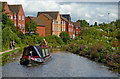
2
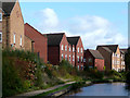
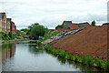
New canalside housing at Kidderminster, Worcestershire
Image: © Roger D Kidd
Taken: 21 Oct 2008
0.04 miles
3
Staffordshire and Worcestershire Canal in Kidderminster
Image: © Mat Fascione
Taken: 4 Apr 2021
0.05 miles
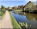
4
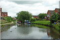
Staffs & Worcs Canal seen from Stourvale New Bridge, Kidderminster
The new housing fronting the canal is in Alder Avenue.
Image: © P L Chadwick
Taken: 10 Mar 2013
0.05 miles
5
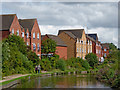
Canal and new building in Kidderminster, Worcestershire
Looking north-east by the new development site on the right where Clensmore Mills used to be. The canal embankment is in the process of being turfed, then planted with trees and shrubs to stabilise the soil and mitigate against erosion.
Staffordshire and Worcestershire Canal.
Image: © Roger Kidd
Taken: 24 Jun 2013
0.05 miles
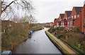
6
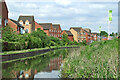
Staffordshire and Worcestershire Canal in Kidderminster, Worcestershire
Looking north-east towards Stourvale New Bridge, No 18. There was originally a footbridge there which served the (nationalised) Stour Vale Iron Works, which closed in April 1962 (?), off to the left.
Image: © Roger Kidd
Taken: 24 Jun 2013
0.06 miles
7
Canalside apartments near Kidderminster in Worcestershire
This is the Staffordshire and Worcestershire Canal at the northern fringe of Kidderminster. On the former Stourvale Iron Works site, the housing, dating from c2007(?) is built around Alder Avenue and Ox Bow Way. The names certainly suggests it has been developed near what was flood prone or potentially wet land. A flood prevention embankment is now in place to control water encroaching from the Stourvale Wetland by the River Stour (off to the left).
Image: © Roger D Kidd
Taken: 23 Aug 2017
0.06 miles
8
Modern housing by the Staffordshire and Worcestershire Canal, Kidderminster
Much of this housing development is on the former Stourvale Iron Works site. Sustrans Route 54 for cyclists diverges from the towpath to the River Stour bank (off to the left) for over five hundred metres here. https://www.sustrans.org.uk/find-a-route-on-the-national-cycle-network/route-54/
Image: © Roger Kidd
Taken: 15 May 2014
0.06 miles
9
![New canalside housing on Alder Avenue [3]](https://s0.geograph.org.uk/geophotos/03/16/10/3161020_577b8966_120x120.jpg)
New canalside housing on Alder Avenue [3]
Near the site of the former Stourvale ironworks, between bridges 17 and 18 on the Staffs and Worcs canal.
Image: © Christine Johnstone
Taken: 3 Sep 2012
0.06 miles
10
Staffordshire and Worcestershire Canal near Kidderminster
This is the Staffordshire and Worcestershire Canal at the northern fringe of Kidderminster. The housing is built on the former Stourvale Iron Works (closed 1962?) around Alder Avenue and Ox Bow Way. The names certainly suggest it has been developed near what was flood prone or potentially wet land. A flood prevention embankment is now in place to control water encroaching from the Stourvale Wetland by the River Stour (off to the left). The area north and west of the housing is now a nature reserve. https://www.wyreforestdc.gov.uk/things-to-see-do-and-visit/countryside-and-nature/nature-reserves/stourvale-nature-reserve.aspx
Image: © Roger D Kidd
Taken: 23 Aug 2017
0.07 miles