IMAGES TAKEN NEAR TO
Church Street, KIDDERMINSTER, DY10 2AD
Introduction
This page details the photographs taken nearby to Church Street, DY10 2AD by members of the Geograph project.
The Geograph project started in 2005 with the aim of publishing, organising and preserving representative images for every square kilometre of Great Britain, Ireland and the Isle of Man.

There are currently over 7.5m images from over14,400 individuals and you can help contribute to the project by visiting https://www.geograph.org.uk
Image Map
Images are licensed for reuse under creativecommons.org/licenses/by-sa/2.0
Notes
- Clicking on the map will re-center to the selected point.
- The higher the marker number, the further away the image location is from the centre of the postcode.
Image Listing (488 Images Found)
Images are licensed for reuse under creativecommons.org/licenses/by-sa/2.0
Image
Details
Distance
1
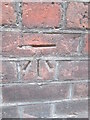
Ordnance Survey Cut Mark
This OS cut mark can be found on No6 Church Street. It marks a point 35.966m above mean sea level.
Image: © Adrian Dust
Taken: 23 Nov 2015
0.00 miles
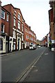
2
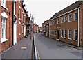
Church Street
In "The Buildings of England Worcestershire" by Brooks & Pevsner (Yale University Press, 2007), Church Street is described as "...the most worthwhile in the town. It has handsome Georgian brick houses on both sides, several with pretty doorcases." Today these houses are mainly used as professional offices. The street itself is a quiet backwater, and comes to a dead end. Originally it terminated in an open space in front of the Parish Church. But now it ends at a turning area, blocked off by the retaining wall of the ring road. Image
Image: © P L Chadwick
Taken: 7 Jun 2009
0.01 miles
3
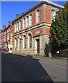
HSBC Bank, 31 Church Street, Kidderminster
Since it was built in 1856-57, this Italianate styled building has housed a succession of banks. It was designed by Thomas Smith for the Stourbridge & Kidderminster Bank. It later came into the hands of the Midland Bank when they absorbed the Stourbridge & Kidderminster Bank long ago. Around 1957 it was doubled in size to the south, but in the same style as the original. In 1992 the bank had been fully acquired by HSBC Holdings plc and in 1999 this branch along with the other surviving Midland Bank branches were rebranded HSBC Bank.
Image: © P L Chadwick
Taken: 17 Feb 2013
0.01 miles
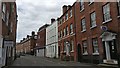
5
Church Street, Kidderminster
The street still has many Georgian buildings and also No. 12, which dates from around 1600. Infortunately the top end was demolished to make way for a section of the ring road. Most of the remaining buildings are in use as offices or by dentists and other professionals.
Image
Image: © P L Chadwick
Taken: 30 Aug 2014
0.01 miles
6
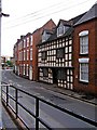
12 Church Street
Sandwiched between Georgian houses, No. 12 Church Street dates from around 1600 and has square-panelled framing. It is Grade II listed. Today it contains various professional offices. Another view:- Image
Image
Image: © P L Chadwick
Taken: 7 Jun 2009
0.02 miles
7
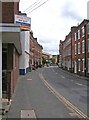
Church Street, looking towards the Bull Ring
The atmosphere of the Bull Ring, seen in the far distance, with its pub, betting office, post office & shops, is much livelier than Church Street, which is where you go for solicitors, dentists and other professional people.
Image: © P L Chadwick
Taken: 7 Jun 2009
0.02 miles
8
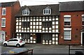
No. 12 Church Street, Kidderminster
One of the oldest buildings in Kidderminster and Grade II listed. Unfortunately the local authority and its predecessors don't have a very good track record for preserving old buildings so an awful lot have been pulled down over the years. Hence the number of surviving listed buildings is not surprisingly quite low for a town of its size and age. This building is thought to date from around 1600 and has square panelled framing. It is used today as offices.
Another view:- Image
Image: © P L Chadwick
Taken: 30 Aug 2014
0.03 miles
9
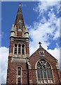
Baxter United Reformed Church
http://www.baxterurc.org.uk/history.html
Image: © Mat Fascione
Taken: 14 Jul 2007
0.03 miles
10
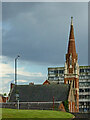
Baxter United Reform Church in Kidderminster
This teleephoto assisted view, looking south-east from the canal towpath shows the church from a distance of almost two hundred metres. The dilapidated Crown House in the Bullring (demolished 2019-2020) is beyond the church. https://www.geograph.org.uk/photo/4145754
Image: © Roger Kidd
Taken: 13 May 2014
0.03 miles