IMAGES TAKEN NEAR TO
Higher Westbury, SHERBORNE, DT9 6RX
Introduction
This page details the photographs taken nearby to Higher Westbury, DT9 6RX by members of the Geograph project.
The Geograph project started in 2005 with the aim of publishing, organising and preserving representative images for every square kilometre of Great Britain, Ireland and the Isle of Man.

There are currently over 7.5m images from over14,400 individuals and you can help contribute to the project by visiting https://www.geograph.org.uk
Image Map
Images are licensed for reuse under creativecommons.org/licenses/by-sa/2.0
Notes
- Clicking on the map will re-center to the selected point.
- The higher the marker number, the further away the image location is from the centre of the postcode.
Image Listing (104 Images Found)
Images are licensed for reuse under creativecommons.org/licenses/by-sa/2.0
Image
Details
Distance
1
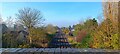
The Railway at Bradford Abbas
The London to Exeter (London and South Western Main Line) railway viewed from Back Lane Bridge looking towards Yeovil Junction.
The village of Bradford Abbas is visible either side of the railway with the tower of the church of St. Mary the Virgin in the left background.
The parapet of Back Lane Bridge, national engineer's reference BAE2 E4/354, is visible in the foreground.
Image: © Emily Ruth Hodges
Taken: 15 Nov 2024
0.07 miles
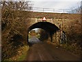
2
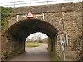
Railway bridge, Bradford Abbas
Once, this railway bridge carrying the Waterloo line across Westbury would have been near the northern edge of the village. Now, since, most recent development has taken place north of it, it is nearer the southern edge. Bishop's Lane, which leads past two closes of such modern houses, turns off to the left just beyond the bridge.
Image: © Derek Harper
Taken: 12 Feb 2010
0.09 miles
4
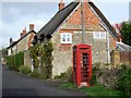
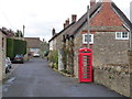
Churchwell Street, Bradford Abbas
A K6 telephone box stands beside pretty cottages on Churchwell Street.
Image: © Maigheach-gheal
Taken: 31 Oct 2009
0.09 miles
6
Bradford Abbas: red telephone box
Looking along Churchwell Street from Church Road.
Image: © Chris Downer
Taken: 27 Mar 2014
0.11 miles
8
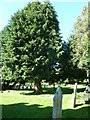
St Mary, Bradford Abbas: churchyard (ii)
Image: © Basher Eyre
Taken: 7 Sep 2012
0.11 miles
9
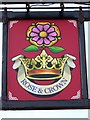
Sign for the Rose and Crown
The sign indicates loyalty to the monarch and to England, and has done so since the early 17th century.
Image: © Maigheach-gheal
Taken: 31 Oct 2009
0.12 miles
10
St Mary, Bradford Abbas: churchyard (vi)
Image: © Basher Eyre
Taken: 7 Sep 2012
0.12 miles