IMAGES TAKEN NEAR TO
Holwell, SHERBORNE, DT9 5LL
Introduction
This page details the photographs taken nearby to DT9 5LL by members of the Geograph project.
The Geograph project started in 2005 with the aim of publishing, organising and preserving representative images for every square kilometre of Great Britain, Ireland and the Isle of Man.

There are currently over 7.5m images from over14,400 individuals and you can help contribute to the project by visiting https://www.geograph.org.uk
Image Map
Images are licensed for reuse under creativecommons.org/licenses/by-sa/2.0
Notes
- Clicking on the map will re-center to the selected point.
- The higher the marker number, the further away the image location is from the centre of the postcode.
Image Listing (7 Images Found)
Images are licensed for reuse under creativecommons.org/licenses/by-sa/2.0
Image
Details
Distance
1
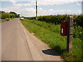
Holwell: postbox № DT9 124
This postbox is towards the eastern end of the village proper and is attached to concrete post roughly outside the former post office. It is emptied finally at 12:30pm on weekdays and at 10am on Saturdays.
Image: © Chris Downer
Taken: 13 Jun 2010
0.04 miles
2
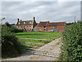
Elm Tree Farm Holwell
The farmhouse is probably early C18, with to the right, early C19 outbuildings. All are Grade II Listed.
Image: © Mike Searle
Taken: 6 Sep 2007
0.12 miles
3
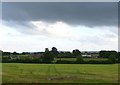
Storm Clouds at Pleck Green
Dark clouds over a recently mown field. In the distance is Elm Tree farm on the left with the houses at Gunville on the right.
Image: © Nigel Mykura
Taken: 30 May 2011
0.17 miles
4
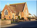
Converted chapel, Holwell
A converted chapel on the road towards King's Stag.
Image: © Maigheach-gheal
Taken: 26 Dec 2008
0.20 miles
5
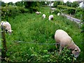
Lush pastures in Pleck Green
These eight rams were enjoying the lush long green vegetation in this small paddock at the side of Stony Lane.
Image: © Nigel Mykura
Taken: 30 May 2011
0.23 miles
6
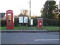
Village communication, Holwell
Notice board, telephone box and a George VI postbox.
Image: © Maigheach-gheal
Taken: 26 Dec 2008
0.23 miles
7
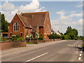
Holwell: a former chapel
The not unusual case of a former chapel converted to residential use.
Image: © Chris Downer
Taken: 13 Jun 2010
0.24 miles