IMAGES TAKEN NEAR TO
Higher Oborne, SHERBORNE, DT9 4RL
Introduction
This page details the photographs taken nearby to DT9 4RL by members of the Geograph project.
The Geograph project started in 2005 with the aim of publishing, organising and preserving representative images for every square kilometre of Great Britain, Ireland and the Isle of Man.

There are currently over 7.5m images from over14,400 individuals and you can help contribute to the project by visiting https://www.geograph.org.uk
Image Map (Loading...)


Getting Data...Please wait
Leaflet Map data © OpenStreetMap
Images are licensed for reuse under creativecommons.org/licenses/by-sa/2.0
Notes
- Clicking on the map will re-center to the selected point.
- The higher the marker number, the further away the image location is from the centre of the postcode.
Image Listing (16 Images Found)
Images are licensed for reuse under creativecommons.org/licenses/by-sa/2.0
Image
Details
Distance
2
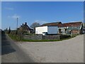
Higher Oborne
Higher Oborne with the Lane heading towards Whitepost Gate
Image: © Shaun Ferguson
Taken: 19 Sep 2007
0.03 miles
3
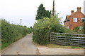
Vale View Farm
This shows one of the larger barns at the farm which is on the north side of Clatcombe Lane just east of White Post Gate.
Image: © Nigel Mykura
Taken: 20 Feb 2012
0.07 miles
4
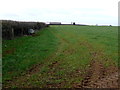
Hidden trig point near Vale View Farm
Was partially visible 5 years ago... Image
Image: © Roger Cornfoot
Taken: 1 Mar 2021
0.07 miles
5
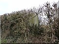
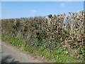
Trigpoint in hedge at Higher Oborne
Image: © Becky Williamson
Taken: 12 Feb 2015
0.08 miles
6
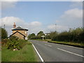
Toll house, north of Sherborne
EH-listed White Post Tollhouse on the Sherborne-Wincanton road, west of Oborne. Stone, 3 sided bay with 2 wings. In the centre, to complete the picture, Dorset fingerpost with gridded finial calling its location White Post Gate.
Image: © Mike Faherty
Taken: 14 Oct 2007
0.12 miles
7
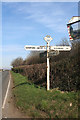
Old Direction Sign - Signpost by the B3145, Oborne Parish
Annulus and bar finial - 4 arms; Dorset halo with NGR by the B3145, in parish of Oborne (West Dorset District), diagonally opposite White Post tollhouse, on grass at junction.
Surveyed
Milestone Society National ID: DO_ST6419A
Image: © Alan Rosevear
Taken: 10 Feb 2008
0.12 miles
8
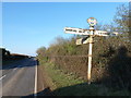
Oborne: finger-post at White Post Gate
Looking north along the B3145 as it coincides roughly with the gridline on the map. One of the traditional Dorset finger-posts with the distinctive roundels, giving location details and six-figure grid reference - see Image for a close-up. It is not in the best of condition, with one finger severely damaged to the extent that it is missing altogether.
Image: © Chris Downer
Taken: 11 Feb 2012
0.13 miles
9
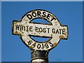
Oborne: detail of White Post Gate signpost
A closer look at the distinctive finial of the Image, which gives the location name and grid reference on it.
Image: © Chris Downer
Taken: 11 Feb 2012
0.13 miles
10
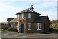
White Post Toll House
Toll House in the parish of Oborne (West Dorset District), Turnpike House, at the junction of Bristol Road and Clatcombe Lane, Higher Oborne, DT9.
Grade II listed.
List Entry Number: 1303964 https://historicengland.org.uk/listing/the-list/list-entry/1303964
Surveyed
Milestone Society National ID: DO.OBO01
Image: © Alan Rosevear
Taken: 10 Feb 2008
0.13 miles