IMAGES TAKEN NEAR TO
Kings Road, SHERBORNE, DT9 4HX
Introduction
This page details the photographs taken nearby to Kings Road, DT9 4HX by members of the Geograph project.
The Geograph project started in 2005 with the aim of publishing, organising and preserving representative images for every square kilometre of Great Britain, Ireland and the Isle of Man.

There are currently over 7.5m images from over14,400 individuals and you can help contribute to the project by visiting https://www.geograph.org.uk
Image Map
Images are licensed for reuse under creativecommons.org/licenses/by-sa/2.0
Notes
- Clicking on the map will re-center to the selected point.
- The higher the marker number, the further away the image location is from the centre of the postcode.
Image Listing (90 Images Found)
Images are licensed for reuse under creativecommons.org/licenses/by-sa/2.0
Image
Details
Distance
2
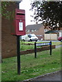
Sherborne: postbox № DT9 99, Harbour Road
This small postbox roughly faces the location of the former Coldharbour Post Office, though there is no sign now of any shop-like buildings. The box is emptied finally at 5:30pm on weekdays and at 12:45pm on Saturdays.
Image: © Chris Downer
Taken: 25 May 2013
0.08 miles
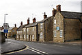
4
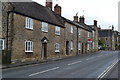
Houses on Coldharbour
"Coldharbour" appears as a single word on the nearby street name sign.
Image: © David Martin
Taken: 30 Apr 2017
0.11 miles
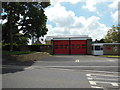
5
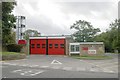
Sherborne Fire Station
Sherborne Fire Station, Coldharbour, Sherborne, Dorset.
Image: © Kevin Hale
Taken: 27 Sep 2006
0.11 miles
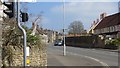
6
Sherborne
The A30 road, looking towards the B3145 Wincanton junction.
Image: © Peter Trimming
Taken: 16 Dec 2014
0.11 miles
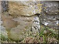
7
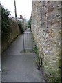
Lane off Cold Harbour with benchmark, Sherborne
Ordnance Survey benchmark, described on database at https://www.bench-marks.org.uk/bm64429. See also
Image: © Becky Williamson
Taken: 12 Feb 2015
0.12 miles
8
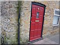
Benchmark, No 6 or 101 Coldharbour, Sherborne (Endcote)
This house is clearly marked as being No. 6 on its house sign, but the Ordnance Survey benchmark database lists it as being No. 101 Coldharbour, indicating a renumbering of the street at some time. For a full description of the benchmark, see http://www.bench-marks.org.uk/bm64429.
Image: © Becky Williamson
Taken: 22 Feb 2015
0.12 miles
9
Cold Harbour, Sherborne
The A30 passes north of the town centre.
Image: © Richard Webb
Taken: 7 Apr 2015
0.14 miles
10
Benchmark, #73 Bristol Road, Sherborne
Ordnance Survey benchmark, described on database at http://www.bench-marks.org.uk/bm64355. See also Image
Image: © Becky Williamson
Taken: 20 Feb 2015
0.15 miles