IMAGES TAKEN NEAR TO
Priestlands Lane, SHERBORNE, DT9 4EY
Introduction
This page details the photographs taken nearby to Priestlands Lane, DT9 4EY by members of the Geograph project.
The Geograph project started in 2005 with the aim of publishing, organising and preserving representative images for every square kilometre of Great Britain, Ireland and the Isle of Man.

There are currently over 7.5m images from over14,400 individuals and you can help contribute to the project by visiting https://www.geograph.org.uk
Image Map
Images are licensed for reuse under creativecommons.org/licenses/by-sa/2.0
Notes
- Clicking on the map will re-center to the selected point.
- The higher the marker number, the further away the image location is from the centre of the postcode.
Image Listing (206 Images Found)
Images are licensed for reuse under creativecommons.org/licenses/by-sa/2.0
Image
Details
Distance
1
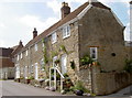
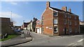
Row of cottages
Some warm-coloured stone cottages in Preistlands Lane. They are at a slight angle to the road so perhaps they were here before the rest of the lane was created.
Image: © Neil Owen
Taken: 15 May 2014
0.05 miles
2
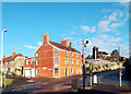
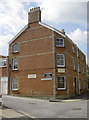
The Old Glove Factory
Sherborne was a centre for glove making. The trade was still thriving up to the 1930s. The local museum has many exhibits about this industry.
History of Dorset glove making on http://dorset-ancestors.com/?p=711
Image: © Des Blenkinsopp
Taken: 26 Aug 2012
0.05 miles
3
The Old Glove Factory, Priestlands Lane, Sherborne
With Ordnance Survey Flush Bracket visible on corner of property. For full description, see http://www.bench-marks.org.uk/bm11835.
Image: © Becky Williamson
Taken: 20 Feb 2016
0.05 miles
5
The Old Glove Factory
Now home to a small number of small businesses, but once an important local employer. See Image] for a look at a flush bracket on the corner of the building.
Image: © Neil Owen
Taken: 15 May 2014
0.06 miles
6
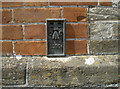
Glovers' flush bracket
This 3GL flush bracket is on the Old Glove Factory on the Bristol Road. See http://www.bench-marks.org.uk/bm11835 for the entry in the Benchmark Database and Image] for a wider view.
Image: © Neil Owen
Taken: 15 May 2014
0.06 miles
8
Antelope Place
Once the Antelope Hotel, it was converted after over a century of business.
Image: © Neil Owen
Taken: 15 May 2014
0.07 miles
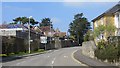
9

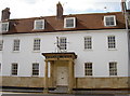
Buildings on Greenhill, Sherborne
These buildings face The Green across the A30 at the top of the town centre. On the left is Abbot's Fee: " Probably early to rid (=mid) C19 front. 3 storey 2 window stone front. Tudor casements with label moulds, probably early to mid C19. Projecting porch of similar date with shafted supports. The front incorporates three carved stone quatrefoil panels, those at the ends being partially covered, one to left hand by a buttress, the other by the return wall of the next house. This suggests that part of the masonry is genuine medieval origin, possibly from Abbot Ramsam's New Inn, demolished circa 1842" http://www.imagesofengland.org.uk/Details/Default.aspx?id=103969&mode=adv , a description which is hard to trace as it is spelt "Abbotts Fee".
On the right is Ramsam House, "Late C18 to early to mid C19. 3-storey, 5 window front, recently roughcast. Chamfered stone quoins. Moulded coping to parapet. Stringcourse. Stone plinth. Sash windows. Good late Georegian doorcase with fluted Tuscan pilasters and entablature; panelled spandrels; fanlight; flush panelled door with top 4 panels cut away and glazed". http://www.imagesofengland.org.uk/Details/Default.aspx?id=103968&mode=adv
Image: © Derek Harper
Taken: 23 Oct 2009
0.07 miles
10
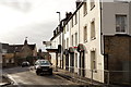
Sherborne
Greenhill, part of the A30.
Image: © Peter Trimming
Taken: 16 Dec 2014
0.07 miles