IMAGES TAKEN NEAR TO
Westcott Terrace, SHERBORNE, DT9 3JP
Introduction
This page details the photographs taken nearby to Westcott Terrace, DT9 3JP by members of the Geograph project.
The Geograph project started in 2005 with the aim of publishing, organising and preserving representative images for every square kilometre of Great Britain, Ireland and the Isle of Man.

There are currently over 7.5m images from over14,400 individuals and you can help contribute to the project by visiting https://www.geograph.org.uk
Image Map
Images are licensed for reuse under creativecommons.org/licenses/by-sa/2.0
Notes
- Clicking on the map will re-center to the selected point.
- The higher the marker number, the further away the image location is from the centre of the postcode.
Image Listing (180 Images Found)
Images are licensed for reuse under creativecommons.org/licenses/by-sa/2.0
Image
Details
Distance
1
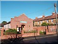
Baptist Church, North Road
The church dates from 1932. http://www.sherbornebaptist.co.uk/about%20us.htm
Image: © Des Blenkinsopp
Taken: 26 Aug 2012
0.04 miles
2
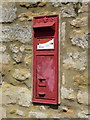
Sherborne: postbox № DT9 31, The Avenue
A Victorian box, which has a damaged information plate.
Image: © Chris Downer
Taken: 25 May 2013
0.06 miles
3
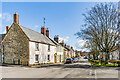
Newland
Looking along Newland with Newland Garden on the right. The nearest building, by the junction with North Road, is 69 Newland, a house with a 19th Century front to an earlier core. Beyond are 71 Newland, dating from the early to mid 19th Century, and the stone fronted 73 - 77 Newland, probably 19th Century. All are grade II listed - see https://historicengland.org.uk/listing/the-list/list-entry/1152607?section=official-list-entry, https://historicengland.org.uk/listing/the-list/list-entry/1110699?section=official-list-entry
Image: © Ian Capper
Taken: 18 Mar 2023
0.08 miles
4
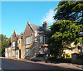
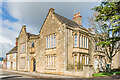
The Manor House, Sherborne
Dating from the 15th or 16th century, this was never actually a manor house. That was apparently just a name some previous occupant used for effect.
It was however at one time The Madame Vantini School for Young Ladies.
It is now home to Sherborne Town Council, who I'm sure are equally genteel.
More info on http://www.sherbornetown.com/sites/Council/759.aspx
Image: © Des Blenkinsopp
Taken: 26 Aug 2012
0.09 miles
5
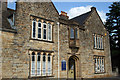
The Manor House
Building thought to date from c.1500. The oriel above the door is original, but was originally on the east side, moved to its current position in c.1820 as part of a "wild sub-gothicization" as described in the Dorset "Buildings of England" volume. The building now houses Sherborne Town Council. Grade II listed - see https://historicengland.org.uk/listing/the-list/list-entry/1110696?section=official-list-entry. Beyond in 41 Newland, also grade II listed - see https://historicengland.org.uk/listing/the-list/list-entry/1110695?section=official-list-entry.
Image: © Ian Capper
Taken: 18 Mar 2023
0.09 miles
6
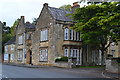
The Manor House, Newland, Sherborne
Grade II Listed house of 15th or 16th century origin with early to mid 19th century Gothic Revival front although the oriel window may be partly original. It was previously occupied by the Durnfords family, Mr Okes a coach master, Mr Beale the Master of the Bristol and Weymouth Wagons, and the Madame Vantini School for Young ladies. The building was purchased by the Town Council from West Dorset District Council who had taken control of it in 1974.
Image: © Jo and Steve Turner
Taken: 11 Sep 2007
0.09 miles
7
The Manor House, Sherborne
Home of the town council.
Image: © David Martin
Taken: 30 Apr 2017
0.09 miles
8
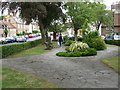
Sherborne: Newland Garden
A small, triangular garden between Fosters and Newland (Newland is the street visible in the background, while parked cars on Fosters can just be seen on the extreme left).
See Image for another view of the garden.
Image: © Chris Downer
Taken: 25 May 2013
0.09 miles
9
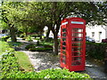
Sherborne: Newland Garden
A small, narrow garden occupying the triangular plot at the junction of St. Swithin's Road and Newland. See Image for a picture of the phone box visible at the far corner.
Image: © Chris Downer
Taken: 14 Jul 2014
0.09 miles
10
Benchmark, No 6 or 101 Coldharbour, Sherborne (Endcote)
This house is clearly marked as being No. 6 on its house sign, but the Ordnance Survey benchmark database lists it as being No. 101 Coldharbour, indicating a renumbering of the street at some time. For a full description of the benchmark, see http://www.bench-marks.org.uk/bm64429.
Image: © Becky Williamson
Taken: 22 Feb 2015
0.09 miles