IMAGES TAKEN NEAR TO
Horsecastles, SHERBORNE, DT9 3HF
Introduction
This page details the photographs taken nearby to Horsecastles, DT9 3HF by members of the Geograph project.
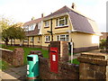
The Geograph project started in 2005 with the aim of publishing, organising and preserving representative images for every square kilometre of Great Britain, Ireland and the Isle of Man.

There are currently over 7.5m images from over14,400 individuals and you can help contribute to the project by visiting https://www.geograph.org.uk
Image Map
Images are licensed for reuse under creativecommons.org/licenses/by-sa/2.0
Notes
- Clicking on the map will re-center to the selected point.
- The higher the marker number, the further away the image location is from the centre of the postcode.
Image Listing (614 Images Found)
Images are licensed for reuse under creativecommons.org/licenses/by-sa/2.0
Image
Details
Distance
1
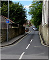
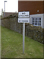
Richmond Road, Sherborne
Viewed across the street named Horsecastles. The sign on the left shows that this is not a through route.
Image: © Jaggery
Taken: 13 May 2015
0.01 miles
2
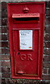
King George V postbox in a Horsecastles wall, Sherborne
Located here. http://www.geograph.org.uk/photo/4478110
Image: © Jaggery
Taken: 13 May 2015
0.03 miles
3
Postbox in a Horsecastles wall, Sherborne
Viewed Horsecastles. The postbox http://www.geograph.org.uk/photo/4478085 is from the reign of King George V (May 1910-January 1936).
Image: © Jaggery
Taken: 13 May 2015
0.03 miles
4
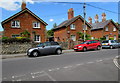
Horsecastles houses and cars, Sherborne
Viewed across the street named Horsecastles from the corner of Old School Place.
Image: © Jaggery
Taken: 13 May 2015
0.04 miles
5
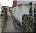
Public footpath from Horsecastles, Sherborne
The path between houses heads SSE away from the street named Horsecastles.
Image: © Jaggery
Taken: 13 May 2015
0.05 miles
6
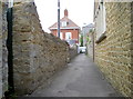
School Lane
An old and rather narrow lane that runs past the Abbey School. Modern housing now forms most of the view, but a benchmark can still be seen on the doorway to the left - see Image
Image: © Neil Owen
Taken: 15 May 2014
0.06 miles
7
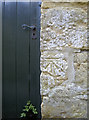
An old way to school
This innocent looking doorway is part of the Abbey School, although it seems they use a different one now. The benchmark on the right is listed in the Benchmark Database: http://www.bench-marks.org.uk/bm45158 . Also see Image] for a wider view.
Image: © Neil Owen
Taken: 15 May 2014
0.06 miles
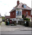
9
Sherborne: postbox № DT9 101, Horsecastles
This George V-reign postbox is emptied finally at 5:30pm on weekdays and at 12:15pm on Saturdays. Behind it, we see Durrant Close, a little development of what appears to be sheltered housing.
Image: © Chris Downer
Taken: 24 Oct 2009
0.06 miles
10
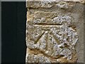
Benchmark on Abbey School, Sherborne
Ordnance Survey benchmark, described on database at http://www.bench-marks.org.uk/bm45158.
Image: © Becky Williamson
Taken: 28 Jul 2015
0.06 miles