IMAGES TAKEN NEAR TO
Hooke, BEAMINSTER, DT8 3NX
Introduction
This page details the photographs taken nearby to DT8 3NX by members of the Geograph project.
The Geograph project started in 2005 with the aim of publishing, organising and preserving representative images for every square kilometre of Great Britain, Ireland and the Isle of Man.

There are currently over 7.5m images from over14,400 individuals and you can help contribute to the project by visiting https://www.geograph.org.uk
Image Map (Loading...)


Getting Data...Please wait
Leaflet Map data © OpenStreetMap
Images are licensed for reuse under creativecommons.org/licenses/by-sa/2.0
Notes
- Clicking on the map will re-center to the selected point.
- The higher the marker number, the further away the image location is from the centre of the postcode.
Image Listing (6 Images Found)
Images are licensed for reuse under creativecommons.org/licenses/by-sa/2.0
Image
Details
Distance
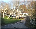
1
Hooke Court
This is now an independent school.
Image: © Chris Downer
Taken: Unknown
0.07 miles
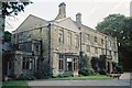
2
Hooke Court
A residential study and holiday centre.
Image: © Roger Cornfoot
Taken: 13 Feb 2023
0.07 miles
3

Small Lake at Hooke
Frozen at the point of our visit
Image: © Chris Heaton
Taken: 25 Jan 2017
0.08 miles
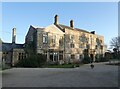
4
Hooke Court - Hooke
Originally a moated manor house many centuries ago, a substantial part of Hooke Court has been demolished - the east wing in the 1960's.
Once the home of Sir Thomas Salt in about the 1920's, the building is now a preparatory school.
Image: © Sarah Smith
Taken: 12 Apr 2009
0.09 miles
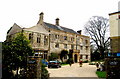
5
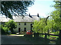
House near Hooke Court
Situated near the stream and ponds, this house is on the corner with Hooke Court nearby.
Hooke used to grow its own watercress.
Image: © Sarah Smith
Taken: 22 May 2010
0.09 miles