IMAGES TAKEN NEAR TO
Naomi Close, BEAMINSTER, DT8 3FQ
Introduction
This page details the photographs taken nearby to Naomi Close, DT8 3FQ by members of the Geograph project.
The Geograph project started in 2005 with the aim of publishing, organising and preserving representative images for every square kilometre of Great Britain, Ireland and the Isle of Man.

There are currently over 7.5m images from over14,400 individuals and you can help contribute to the project by visiting https://www.geograph.org.uk
Image Map
Images are licensed for reuse under creativecommons.org/licenses/by-sa/2.0
Notes
- Clicking on the map will re-center to the selected point.
- The higher the marker number, the further away the image location is from the centre of the postcode.
Image Listing (11 Images Found)
Images are licensed for reuse under creativecommons.org/licenses/by-sa/2.0
Image
Details
Distance
1
Windsor Close - Mosterton
The outskirts of Mosterton from the south. The houses lie on a lane off the A3066 which leads to Littlewindsor.
Image: © Sarah Smith
Taken: 30 Mar 2010
0.03 miles
2

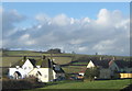
Houses at the southern end of Mosterton
Image: © Roger Cornfoot
Taken: 13 Mar 2019
0.05 miles
3
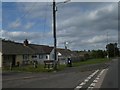
Mosterton village sign, Mosterton Cross
Image: © David Smith
Taken: 20 Aug 2019
0.08 miles
4
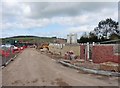
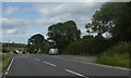
New housing development, near Mosterton
Image: © Roger Cornfoot
Taken: 13 Mar 2019
0.10 miles
6
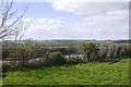
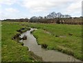
Field near Mosterton
Beside the A3066.
Image: © Richard Webb
Taken: 10 Apr 2017
0.10 miles
9
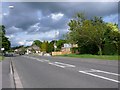
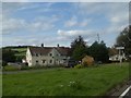
Mosterton
This is the main street running through the village at the southern end where it is mostly recently-built houses.
Image: © Nigel Mykura
Taken: 13 May 2011
0.20 miles