IMAGES TAKEN NEAR TO
Yawl Crescent, LYME REGIS, DT7 3XL
Introduction
This page details the photographs taken nearby to Yawl Crescent, DT7 3XL by members of the Geograph project.
The Geograph project started in 2005 with the aim of publishing, organising and preserving representative images for every square kilometre of Great Britain, Ireland and the Isle of Man.

There are currently over 7.5m images from over14,400 individuals and you can help contribute to the project by visiting https://www.geograph.org.uk
Image Map
Images are licensed for reuse under creativecommons.org/licenses/by-sa/2.0
Notes
- Clicking on the map will re-center to the selected point.
- The higher the marker number, the further away the image location is from the centre of the postcode.
Image Listing (9 Images Found)
Images are licensed for reuse under creativecommons.org/licenses/by-sa/2.0
Image
Details
Distance
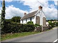
1
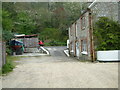
Yawl, Devon
This house is by a narrow steep road. Moving the boat could be very interesting.
Image: © Stuart Buchan
Taken: 6 May 2006
0.02 miles
4
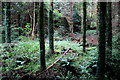
Woods in Yawl Bottom
The woods in the forest here are mainly Scots pine although there are a small number of broadleaved trees.
Image: © Nigel Mykura
Taken: 29 Sep 2017
0.09 miles
6
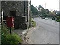
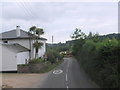
Yawl: postbox № DT7 42
I had just watched the postman stop to empty this box – but there was nothing inside. You can see his van farther down the street, continuing his deliveries. This postbox is a sensible replacement to a Victorian one opposite: this one is in a layby and is thus far more convenient for customers and postman alike, since the old one is set into a wall directly abutting the road.
See Image
Image: © Chris Downer
Taken: 27 Sep 2008
0.14 miles
7
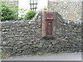
Yawl: redundant Victorian postbox
This postbox has been replaced by a modern one opposite: see Image The replacement is far more sensibly located, since it is in a layby – much safer for those posting and collecting letters – whereas this one directly abuts what must be a far busier road than when it was installed.
Image: © Chris Downer
Taken: 27 Sep 2008
0.14 miles
8
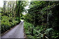
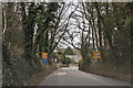
Road Through Yawl Bottom
At first after leaving the Uplyme Road, the lane runs along the side of the stream (seen here on the right) but then it bends to the left and climbs up out of the bottom and up to St Mary's Lane which follows the contours along the valley side above the bottom before dropping back down and rejoining the Uplyme Road.
Image: © Nigel Mykura
Taken: 29 Sep 2017
0.18 miles
9
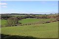
View Across Carswell Bottom
One side of the valley is known as Carswell Bottom the other as Rocombe Bottom. On the other side of the further hill is the valley containing the village of Yawl.
Image: © Nigel Mykura
Taken: 12 Mar 2017
0.22 miles