IMAGES TAKEN NEAR TO
Whalley Lane, LYME REGIS, DT7 3UR
Introduction
This page details the photographs taken nearby to Whalley Lane, DT7 3UR by members of the Geograph project.
The Geograph project started in 2005 with the aim of publishing, organising and preserving representative images for every square kilometre of Great Britain, Ireland and the Isle of Man.

There are currently over 7.5m images from over14,400 individuals and you can help contribute to the project by visiting https://www.geograph.org.uk
Image Map
Images are licensed for reuse under creativecommons.org/licenses/by-sa/2.0
Notes
- Clicking on the map will re-center to the selected point.
- The higher the marker number, the further away the image location is from the centre of the postcode.
Image Listing (30 Images Found)
Images are licensed for reuse under creativecommons.org/licenses/by-sa/2.0
Image
Details
Distance
1
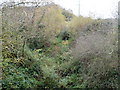
Route of dismantled railway
At Gore Lane looking eastwards from bridge over route of Axminster and Lyme Regis Light Railway, opened on 24 August 1903 and closed 29 November 1965.
Image: © Peter Holmes
Taken: 14 Nov 2008
0.06 miles
2
Gore Lane bridge
Bridge over route of the now closed Axminster and Lyme Regis Light Railway. Uplyme can be seen in the distance.
Image: © Peter Holmes
Taken: 14 Nov 2008
0.08 miles
3
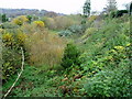
Route of dismantled railway
At Gore Lane looking westwards from bridge over route of Axminster and Lyme Regis Light Railway, opened on 24 August 1903 and closed 29 November 1965.
Image: © Peter Holmes
Taken: 14 Nov 2008
0.09 miles
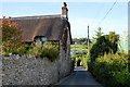
4
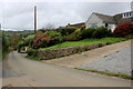
House in Uplyme
This chalet style bungalow with extension sits on Gore Lane which runs from the centre of Uplyme south uphill to the hamlet of Ware, close to the top of Ware Cliffs overlooking the sea just west of Lyme Regis.
Image: © Nigel Mykura
Taken: 29 Sep 2017
0.11 miles
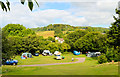
5
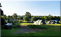
Hook Farm camping site, Uplyme
A highly regarded site among campers - with justification.
Image: © Philip Pankhurst
Taken: 13 Jul 2013
0.14 miles
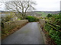
7

Gore Lane, Uplyme
A familiar walk for Hook Farm campers, leading to the Talbot Arms on the main road.
Image: © Philip Pankhurst
Taken: 16 Jul 2014
0.16 miles
8
Gore Lane, Uplyme
A familiar walk for Hook Farm campers, leading to the Talbot Arms on the main road.
Image: © Philip Pankhurst
Taken: 16 Jul 2014
0.18 miles
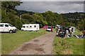
10
Hook Farm campsite
The many very favourable reviews have it just about right; an excellent site - ideal for the Jurassic Coast and Lyme Bay.
Image: © Philip Pankhurst
Taken: 15 Jul 2014
0.18 miles