IMAGES TAKEN NEAR TO
Spring Head Road, LYME REGIS, DT7 3UH
Introduction
This page details the photographs taken nearby to Spring Head Road, DT7 3UH by members of the Geograph project.
The Geograph project started in 2005 with the aim of publishing, organising and preserving representative images for every square kilometre of Great Britain, Ireland and the Isle of Man.

There are currently over 7.5m images from over14,400 individuals and you can help contribute to the project by visiting https://www.geograph.org.uk
Image Map
Images are licensed for reuse under creativecommons.org/licenses/by-sa/2.0
Notes
- Clicking on the map will re-center to the selected point.
- The higher the marker number, the further away the image location is from the centre of the postcode.
Image Listing (68 Images Found)
Images are licensed for reuse under creativecommons.org/licenses/by-sa/2.0
Image
Details
Distance
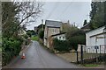
3
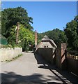
The East Devon Way on the River Lim Path
About to cross Spring Head Road
Image: © Tim Heaton
Taken: 7 Feb 2024
0.10 miles
4
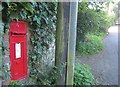
Postbox, Uplyme
Edward VII postbox number DT7 41 is on Tapper's Knapp opposite Mill Lane, and can be admired by those following the East Devon Way, which turns into Uplyme Footpath 63 just behind the telegraph pole.
Image: © Derek Harper
Taken: 31 Jul 2015
0.10 miles
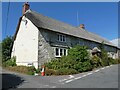
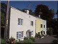
5
Cottage, Uplyme
This listed cottage http://www.historicengland.org.uk/listing/the-list/list-entry/1333640 is beside the East Devon Way. The River Lim flows past it on the right.
Image: © Derek Harper
Taken: 31 Jul 2015
0.12 miles
6
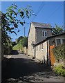
Cottage, Uplyme
Knapp Cottage is on a steep section of Church Street.
Image: © Derek Harper
Taken: 31 Jul 2015
0.17 miles
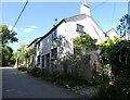
7
Cottages, Uplyme
Three cottages on Church Street just above the bridge over the Lim. The East Devon Way crosses the road where the camera position is.
Image: © Derek Harper
Taken: 31 Jul 2015
0.17 miles
8
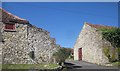
Court Hall Farm, Uplyme
On the left is the stable range http://www.historicengland.org.uk/listing/the-list/list-entry/1171523 ; on the right, the cattle shed http://www.historicengland.org.uk/listing/the-list/list-entry/1098362 . Another listed building including pigstys http://www.historicengland.org.uk/listing/the-list/list-entry/1333641 , can be seen between them. Three further buildings are also listed. Seen across Pound Lane.
Image: © Derek Harper
Taken: 31 Jul 2015
0.18 miles
9
Church Street, Uplyme
The East Devon Way (fingerpost right) follows the River Lim Path to Lyme Regis
Image: © Tim Heaton
Taken: 7 Feb 2024
0.18 miles
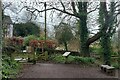
10
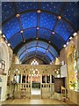
Uplyme - Church
The church of St Peter and St Paul is mediaeval but heavily restored in 1876. Inside, the blue wagon roof of the Nave and Chancel is painted with gold stars.
Inside the parish church, St Peter and St Paul.
www.uplymechurch.org.uk
Image: © Colin Smith
Taken: 20 Jun 2019
0.18 miles