IMAGES TAKEN NEAR TO
Cannington Lane, LYME REGIS, DT7 3SW
Introduction
This page details the photographs taken nearby to Cannington Lane, DT7 3SW by members of the Geograph project.
The Geograph project started in 2005 with the aim of publishing, organising and preserving representative images for every square kilometre of Great Britain, Ireland and the Isle of Man.

There are currently over 7.5m images from over14,400 individuals and you can help contribute to the project by visiting https://www.geograph.org.uk
Image Map
Images are licensed for reuse under creativecommons.org/licenses/by-sa/2.0
Notes
- Clicking on the map will re-center to the selected point.
- The higher the marker number, the further away the image location is from the centre of the postcode.
Image Listing (25 Images Found)
Images are licensed for reuse under creativecommons.org/licenses/by-sa/2.0
Image
Details
Distance
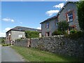
2
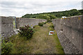
Trackbed Cannington Viaduct
Few photographers seem to have bush-wacked their way to the top of the disused viaduct so I took the liberty to investigate myself.
Image: © Noel Jenkins
Taken: 17 Jul 2010
0.10 miles
4
Pinhay : Cannington Viaduct
For more information see Image
Image: © Jim Osley
Taken: 17 Jul 2018
0.10 miles
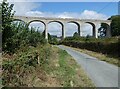
5
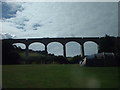
Cannington Viaduct
The viaduct at Cannington was on the railway from Axminster to Lyme Regis. It was built of concrete at the beginning of the last century.
Image: © ANDY FISH
Taken: 30 Aug 2006
0.10 miles
7
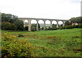
Cannington Viaduct
By far the most photographed object in this square and quite rightly so as it was a groundbreaker being one of the earliest unreinforced concrete viaducts ever built in 1903 by McAlpine the builder. It carried a now dismantled railway.
Image: © Nigel Mykura
Taken: 29 Sep 2017
0.11 miles
8
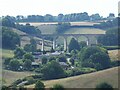
Cannington viaduct
This viaduct was one of the first concrete viaducts built by Robert Mccalpine in 1903. There was subsidence at the base of the third arch and it was necessary to build a brick reinforcing arch seen in this view. For a short period after the railway opened a watchman was stationed at the end of the viaduct to check for movement.
Image: © ANDY FISH
Taken: 27 Apr 2004
0.11 miles
9
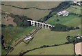
Cannington viaduct from the air
This viaduct was once part of the old branch line from Axminster to Lyme Regis which closed in 1965. The photo was taken from a passenger plane approaching Exeter airport. During the original construction which was in solid concrete, the builders had to fill in the arch on the left when they encountered subsidence between two of the arches.
To see a full 360° Panorama of this viaduct please visit this http://www.360panoramas.co.uk/index.php?page=Cannington+Viaduct§ion=4&id=94
Image: © M Etherington
Taken: 19 Sep 2006
0.11 miles
10

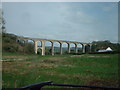
Cannington Viaduct
At the time of submission, twelve of the fourteen images for the square show this viaduct, with good descriptions - see especially Image and Image, which shows the spot at the angle of hedge by the building down to the left of the viaduct where I took this, on Uplyme Bridleway 6. But I can at least offer a link to the listed building description at http://list.historicengland.org.uk/resultsingle.aspx?uid=1305643&searchtype=mapsearch .
Image: © Derek Harper
Taken: 31 Jul 2015
0.11 miles