IMAGES TAKEN NEAR TO
Venlake Lane, LYME REGIS, DT7 3SG
Introduction
This page details the photographs taken nearby to Venlake Lane, DT7 3SG by members of the Geograph project.
The Geograph project started in 2005 with the aim of publishing, organising and preserving representative images for every square kilometre of Great Britain, Ireland and the Isle of Man.

There are currently over 7.5m images from over14,400 individuals and you can help contribute to the project by visiting https://www.geograph.org.uk
Image Map
Images are licensed for reuse under creativecommons.org/licenses/by-sa/2.0
Notes
- Clicking on the map will re-center to the selected point.
- The higher the marker number, the further away the image location is from the centre of the postcode.
Image Listing (33 Images Found)
Images are licensed for reuse under creativecommons.org/licenses/by-sa/2.0
Image
Details
Distance
2
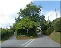
East Devon Way
Public footpath to Uplyme.
Image: © Peter Holmes
Taken: 14 Nov 2008
0.08 miles
3
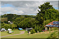
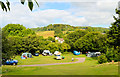
Hook Farm campsite, Uplyme
The many very favourable reviews have it just about right; an excellent site - ideal for the Jurassic Coast and Lyme Bay.
Image: © Philip Pankhurst
Taken: 15 Jul 2014
0.11 miles
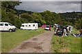
5
Hook Farm campsite
The many very favourable reviews have it just about right; an excellent site - ideal for the Jurassic Coast and Lyme Bay.
Image: © Philip Pankhurst
Taken: 15 Jul 2014
0.12 miles
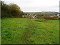
7

Woodhouse Lane taking the East Devon Way down to Uplyme
Lyme Regis, the end of the East Devon Way, lies behind the wooded hill on the horizon.
Image: © Tim Heaton
Taken: 7 Feb 2024
0.15 miles
8
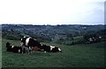
Uplyme from Whitty Hill
Uplyme is seen centre and left of the photo. To the right, Cannington Viaduct Image can be seen with a chalk quarry behind it. The viaduct was one of the first mass (unreinforced) concrete viaducts in Britain, and carried the branch line to Lyme Regis which opened in 1903 and closed in 1965.
Although nearby Lyme Regis is in Dorset, Uplyme and everything in this photo is in Devon.
Image: © David Purchase
Taken: 17 May 1966
0.15 miles
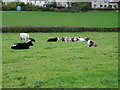
9
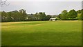
Uplyme & Lyme Regis Cricket Club
Uplyme & Lyme Regis's King George V Playing Fields ground. The club must be one of very few who represent places in two different counties, Uplyme in (East) Devon and Lyme Regis in Dorset.
Image: © BatAndBall
Taken: 6 May 2017
0.15 miles
10
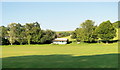
King George's Field, Uplyme
Home to Uplyme and Lyme Regis Cricket Club. This is the old pavilion, I believe, as there is a swanky new one opposite. Exactly 12 months ago this area suffered serious flooding. A complete recovery has been achieved, thankfully.
Image: © Philip Pankhurst
Taken: 9 Jul 2013
0.15 miles