IMAGES TAKEN NEAR TO
Bridge Road, BRIDPORT, DT6 6QP
Introduction
This page details the photographs taken nearby to Bridge Road, DT6 6QP by members of the Geograph project.
The Geograph project started in 2005 with the aim of publishing, organising and preserving representative images for every square kilometre of Great Britain, Ireland and the Isle of Man.

There are currently over 7.5m images from over14,400 individuals and you can help contribute to the project by visiting https://www.geograph.org.uk
Image Map (Loading...)


Getting Data...Please wait
Leaflet Map data © OpenStreetMap
Images are licensed for reuse under creativecommons.org/licenses/by-sa/2.0
Notes
- Clicking on the map will re-center to the selected point.
- The higher the marker number, the further away the image location is from the centre of the postcode.
Image Listing (123 Images Found)
Images are licensed for reuse under creativecommons.org/licenses/by-sa/2.0
Image
Details
Distance
1
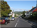
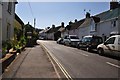
Charmouth, Dorset
Looking East down the main street through the village. The Jurassic beach is off to the right, down a side road.
Image: © Derek Voller
Taken: 14 Sep 2009
0.02 miles
2
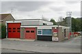
Charmouth fire station
Charmouth fire station, Bridge Road, Charmouth, is station number 02 of the Dorset Fire & Rescue Service.
Image: © Kevin Hale
Taken: 10 Aug 2006
0.03 miles
4
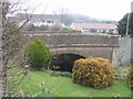
Keep your hands off my bridge or else!
A one way trip awaits the local vandals. What would today's County Surveyors make of this as a way of deterring graffiti. The bridge Image appears to have been re-constructed in 1823 and I assume the sign dates from that time. Transportation to Australia was carried out between 1780 and 1868.
Image: © John M
Taken: 26 Feb 2009
0.04 miles
5
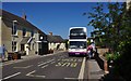
Charmouth : The Street
A street in Charmouth called The Street. The First bus was on its way towards Exeter.
Image: © Lewis Clarke
Taken: 6 Jul 2013
0.04 miles
6
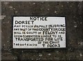
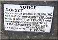
Old Bridge Marker on Charmouth Bridge, The Street, Charmouth
Bridge Marker by the UC road (was A35), in parish of Charmouth (West Dorset District), Charmouth Bridge, South side of road
Inscription reads:-
DORSET
ANY PERSON WILFULLY INJURING
ANY PART OF THIS COUNTY BRIDGE
WILL BE GUILTY OF FELONY AND
UPON CONVICTION LIABLE TO BE
TRANSPORTED FOR LIFE
BY THE COURT
7&8 GEO 4 C30 S13 T FOOKS
Dorset HER.
HER Number: MDO20626 https://www.heritagegateway.org.uk/Gateway/Results_Single.aspx?uid=MDO20626&resourceID=1012
Surveyed
Milestone Society National ID: DO_TRACHAbr
Image: © Milestone Society
Taken: Unknown
0.04 miles
7
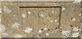
Old Boundary Marker
Bridge Marker set in the north parapet of Charmouth Bridge. Charmouth parish. Inscribed D C C / 1957.
Milestone Society National ID: DO_TRACHA02br
Image: © J Glew
Taken: 30 Sep 2020
0.04 miles
8
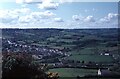
Charmouth from Stonebarrow Hill
At the time this was taken in 1966, the main A35 went through the village along the line running diagonally down from left to right. The bypass, not opened until 1990, runs about 300 metres (two field widths) further inland.
Image: © David Purchase
Taken: 18 May 1966
0.04 miles
9
Charmouth : The Street
The Street in Charmouth - not the most exciting road name in the world.
Image: © Lewis Clarke
Taken: 6 Jul 2013
0.05 miles
10
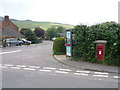
Charmouth: postbox № DT6 70 and phone, Bridge Road
An Elizabeth-II reign postbox set into a brick pillar and serving the eastern end of Charmouth. It's emptied at 4:45pm on weekdays and at 11am on Saturdays.
Image: © Chris Downer
Taken: 13 Jun 2009
0.06 miles