IMAGES TAKEN NEAR TO
Seatown, Chideock, BRIDPORT, DT6 6JU
Introduction
This page details the photographs taken nearby to DT6 6JU by members of the Geograph project.
The Geograph project started in 2005 with the aim of publishing, organising and preserving representative images for every square kilometre of Great Britain, Ireland and the Isle of Man.

There are currently over 7.5m images from over14,400 individuals and you can help contribute to the project by visiting https://www.geograph.org.uk
Image Map
Images are licensed for reuse under creativecommons.org/licenses/by-sa/2.0
Notes
- Clicking on the map will re-center to the selected point.
- The higher the marker number, the further away the image location is from the centre of the postcode.
Image Listing (185 Images Found)
Images are licensed for reuse under creativecommons.org/licenses/by-sa/2.0
Image
Details
Distance
1
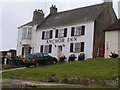
Anchor Inn, Seatown
Very welcoming coastal pub.
Image: © N Chadwick
Taken: 30 Dec 2006
0.00 miles
2
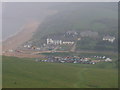
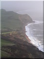
Seatown, looking down from the east
Image: © Stephen Parkinson
Taken: 31 May 2003
0.01 miles
3
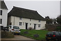
Anchor Cottage, Seatown
Grade II listed. http://www.britishlistedbuildings.co.uk/en-401226-anchor-cottage-chideock
Image: © N Chadwick
Taken: 30 Dec 2011
0.02 miles
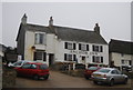
6
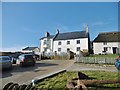
Seatown, Anchor Inn
Beautifully located public house at the end of Sea Hill Lane, overlooking the sea. Internally, back bar with two eating/drinking rooms to the front, and another side room left. Some exposed stonework, open fires, panelled ceiling, dried hops, old photos and garden. Cask ales on offer at my visit: Palmers 200, Copper, Dorset Gold, IPA.
Image: © Mike Faherty
Taken: 11 Jan 2018
0.02 miles
7
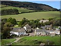
Seatown
Buildings clustered around Sea Hill Lane. The fine L-shaped building on the left is Seatown Farmhouse, dating from about 1700 http://list.english-heritage.org.uk/resultsingle.aspx?uid=1287860&searchtype=mapsearch . Behind, the west side of the Winniford valley climbs to the wooded Langdon Hill. View from the coast path.
Image: © Derek Harper
Taken: 29 Sep 2012
0.03 miles
8
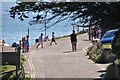
Seatown : Sea Hill Lane
Sea Hill Lane heads towards the coastline at Seatown.
Image: © Lewis Clarke
Taken: 6 Jul 2013
0.03 miles
9

Seatown: the Anchor Inn pub sign
Looking down on the pub sign from the beer garden, the public car park beyond.
Image: © Chris Downer
Taken: 13 Jun 2009
0.03 miles
10

Seafront houses
The Anchor Inn in Golden Cap Holiday Park, Seatown, Dorset.
Image: © peter maddison
Taken: 11 Aug 2010
0.03 miles