IMAGES TAKEN NEAR TO
Symondsbury, BRIDPORT, DT6 6HF
Introduction
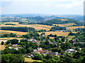
This page details the photographs taken nearby to DT6 6HF by members of the Geograph project.
The Geograph project started in 2005 with the aim of publishing, organising and preserving representative images for every square kilometre of Great Britain, Ireland and the Isle of Man.

There are currently over 7.5m images from over14,400 individuals and you can help contribute to the project by visiting https://www.geograph.org.uk
Image Map
Images are licensed for reuse under creativecommons.org/licenses/by-sa/2.0
Notes
- Clicking on the map will re-center to the selected point.
- The higher the marker number, the further away the image location is from the centre of the postcode.
Image Listing (160 Images Found)
Images are licensed for reuse under creativecommons.org/licenses/by-sa/2.0
Image
Details
Distance
1
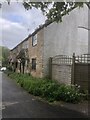
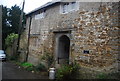
Dressed to show
Shute cottages.
A classic example of being dressed to show.
Local warm limestone is used to face the road. Giving kerb appeal.
The sides and rear are however just masonry bricks.
Image: © Anthony Vosper
Taken: 20 May 2021
0.02 miles
3
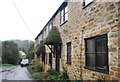
Symondsbury, Shute's Farm Cottages
On Shute's Lane. The converted cottages were once a barn and cart shed. C19, listed by Historic England: http://www.imagesofengland.org.uk/Details/Default.aspx?id=401685&mode=adv
Image: © Mike Faherty
Taken: 28 Mar 2017
0.02 miles
5
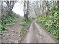
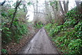
Symondsbury, Shute's Lane
Public route (as Dorset CC calls it), or other route with public access (OS's language). Lane from the village to Quarry Cross; higher up, it becomes a holloway, and there is a fallen rock. Springtime plants in bloom noticed: moschatel, dog's mercury, primrose, currant.
Image: © Mike Faherty
Taken: 28 Mar 2017
0.03 miles
6
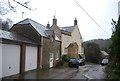
The Rectory, Symondsbury
Grade II listed. http://www.britishlistedbuildings.co.uk/en-401640-the-rectory-symondsbury
Image: © N Chadwick
Taken: 30 Dec 2011
0.04 miles
7
Buildings at Symondsbury
On Shute's Lane. On the left is the former rectory http://www.historicengland.org.uk/listing/the-list/list-entry/1216294 . To this side of it, largely in shadow, are its former stables http://www.historicengland.org.uk/listing/the-list/list-entry/1216295 . On the right are the former barn and cart shed at Shute's Farm http://www.historicengland.org.uk/listing/the-list/list-entry/1216334 .
Image: © Derek Harper
Taken: 31 Oct 2015
0.04 miles
8
Shute's Farmhouse
Grade II listed. http://www.britishlistedbuildings.co.uk/en-401684-shute-s-farmhouse-symondsbury
Image: © N Chadwick
Taken: 30 Dec 2011
0.04 miles
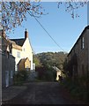
9
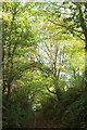
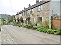
Shute's Lane
Sunken slightly, the tree-enclosed route with public access drops to the village, with the car denoting where the public road begins.
Image: © Derek Harper
Taken: 31 Oct 2015
0.05 miles