IMAGES TAKEN NEAR TO
Higher Sea Lane, BRIDPORT, DT6 6AZ
Introduction
This page details the photographs taken nearby to Higher Sea Lane, DT6 6AZ by members of the Geograph project.
The Geograph project started in 2005 with the aim of publishing, organising and preserving representative images for every square kilometre of Great Britain, Ireland and the Isle of Man.

There are currently over 7.5m images from over14,400 individuals and you can help contribute to the project by visiting https://www.geograph.org.uk
Image Map
Images are licensed for reuse under creativecommons.org/licenses/by-sa/2.0
Notes
- Clicking on the map will re-center to the selected point.
- The higher the marker number, the further away the image location is from the centre of the postcode.
Image Listing (119 Images Found)
Images are licensed for reuse under creativecommons.org/licenses/by-sa/2.0
Image
Details
Distance
2
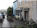
A shop that sells Pots and trinkets
Here we look down toward the bottom of the village taking in this quaint shop near Higher Sea Lane
Image: © Ant Basterfield
Taken: 28 Oct 2010
0.06 miles
3
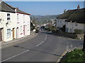
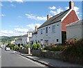
The Street, Charmouth
Presumably The Street used to be the main road passing through Charmouth until a bypass was built.
Image: © Philip Halling
Taken: 2 Apr 2012
0.07 miles
5
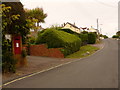
Charmouth: postbox № DT6 79, Higher Sea Lane
A George VI-reign postbox set into a brick pillar, emptied at 5pm on weekdays and at 8am on Saturdays.
Image: © Chris Downer
Taken: 13 Jun 2009
0.07 miles
6
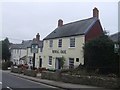
Royal Oak - Charmouth
Marking the passage of King Charles through nearby Bridport. Charmouth itself features on the 'Monarch's Way' as the first place on the south coast where the king tried to take a boat into exile but was thwarted.
Image
Image: © John M
Taken: 25 Feb 2009
0.07 miles
7
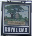
Royal Oak - Charmouth
The pub name celebrates King Charles II's escape by hiding in an oak tree at Boscobel, Shropshire after the battle of Worcester. King Charles II stayed at the nearby Queene's Arms in Charmouth where he failed in his attempt to find a boat to take him to France. The pub sign shows a commemoration stone in Bridport.
Image: © John M
Taken: 25 Feb 2009
0.08 miles
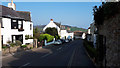
8
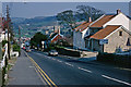
The Street, Charmouth
Charmouth is a large Dorset village with a population of about 1,300. This view looks down its main street into the valley of the River Char along what was then the A35, but has since been by-passed.
Image: © Stephen McKay
Taken: Unknown
0.08 miles
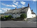
10
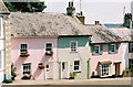
Charmouth: pastel cottages
Cottages on the Axminster Road, Chideock, their pastel colours catching the sun.
Image: © Chris Downer
Taken: 31 Jul 2004
0.09 miles