IMAGES TAKEN NEAR TO
Pymore, BRIDPORT, DT6 5PP
Introduction
This page details the photographs taken nearby to DT6 5PP by members of the Geograph project.
The Geograph project started in 2005 with the aim of publishing, organising and preserving representative images for every square kilometre of Great Britain, Ireland and the Isle of Man.

There are currently over 7.5m images from over14,400 individuals and you can help contribute to the project by visiting https://www.geograph.org.uk
Image Map
Images are licensed for reuse under creativecommons.org/licenses/by-sa/2.0
Notes
- Clicking on the map will re-center to the selected point.
- The higher the marker number, the further away the image location is from the centre of the postcode.
Image Listing (23 Images Found)
Images are licensed for reuse under creativecommons.org/licenses/by-sa/2.0
Image
Details
Distance
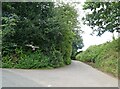
3
Ebenezer Corner, Wooth
Another intriguing name for a corner. The minor road goes past Wooth Farm to Waytown and Netherbury.
Image: © Becky Williamson
Taken: 13 Sep 2018
0.02 miles
4
Brit valley
From the lane at Wooth. Across the river on the right is Watford Farm, in Image
Image: © Derek Harper
Taken: 12 Apr 2016
0.07 miles
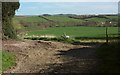
5

Field beside the River Brit
The right-hand side of this field wiggles in and out as it follows the course of the river upstream. 60 metres from the camera, the line of vision crosses into Image
Image: © Derek Harper
Taken: 13 Mar 2017
0.09 miles
6
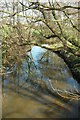
River Brit
Looking upstream from Watford Bridge https://www.historicengland.org.uk/listing/the-list/list-entry/1288868 . The river is followed by the parish boundary between Bradpole (right) and Netherbury.
Image: © Derek Harper
Taken: 13 Mar 2017
0.09 miles
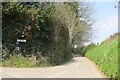
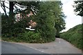
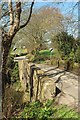
7
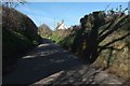
Lane at Wooth
The gable end of a pair of cottages, seen as the lane climbs from the junction with Pymore Lane.
Image: © Derek Harper
Taken: 12 Apr 2016
0.09 miles
8
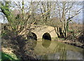
Bridge over the Brit at Pymore
This lovely old bridge is hardly noticeable if you drive over it, but the short wallow into a muddy field to take the picture was worth the effort.
Image: © Stephen Williams
Taken: 26 Feb 2007
0.10 miles
9
Watford Bridge
The bridge carrying Pymore Lane over River Brit is listed and described at https://www.historicengland.org.uk/listing/the-list/list-entry/1288868 : "C17, or earlier". The lane is used by NCN2.
Image: © Derek Harper
Taken: 13 Mar 2017
0.10 miles
10
Watford Bridge
The bridge carrying Pymore Lane (and NCN2) over River Brit is listed and described at https://www.historicengland.org.uk/listing/the-list/list-entry/1288868 : "C17, or earlier".
Image: © Derek Harper
Taken: 13 Mar 2017
0.10 miles