IMAGES TAKEN NEAR TO
Pymore, BRIDPORT, DT6 5PH
Introduction
This page details the photographs taken nearby to DT6 5PH by members of the Geograph project.
The Geograph project started in 2005 with the aim of publishing, organising and preserving representative images for every square kilometre of Great Britain, Ireland and the Isle of Man.

There are currently over 7.5m images from over14,400 individuals and you can help contribute to the project by visiting https://www.geograph.org.uk
Image Map
Images are licensed for reuse under creativecommons.org/licenses/by-sa/2.0
Notes
- Clicking on the map will re-center to the selected point.
- The higher the marker number, the further away the image location is from the centre of the postcode.
Image Listing (38 Images Found)
Images are licensed for reuse under creativecommons.org/licenses/by-sa/2.0
Image
Details
Distance
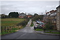
1
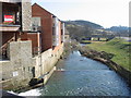
Monarch's Way, Pymore
Re-crossing the River Brit the Monarch's Way starts to climb away from the coast.
Image: © John M
Taken: 27 Feb 2008
0.03 miles
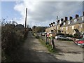
2
Pymore Terrace
Route of the Monarch's Way.
Image: © N Chadwick
Taken: 1 Jan 2012
0.04 miles
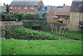
6

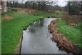
Pymore: overlooking the River Brit
Two benches overlook the Brit as it flows towards us through modern housing in Pymore, on its way to the sea at West Bay, Bridport.
Image: © Chris Downer
Taken: 13 Jun 2009
0.06 miles
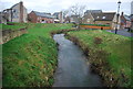
7
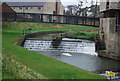
River Brit at Pymore
The River Brit (right fork) is joined from the left by a stream which has just crossed a weir, beyond which is a large pond. The housing development is only a few years old, and incorporates many old features - much of the site was once industrial.
Image: © Stephen Williams
Taken: 6 Mar 2007
0.06 miles
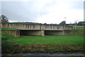
8
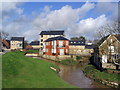
Bridge over River Brit, Pymore
Grade II listed. http://www.britishlistedbuildings.co.uk/en-398525-bridge-to-present-managers-office-at-pym
Image: © N Chadwick
Taken: 1 Jan 2012
0.06 miles