IMAGES TAKEN NEAR TO
Templemans Ash, BRIDPORT, DT6 5NX
Introduction
This page details the photographs taken nearby to DT6 5NX by members of the Geograph project.
The Geograph project started in 2005 with the aim of publishing, organising and preserving representative images for every square kilometre of Great Britain, Ireland and the Isle of Man.

There are currently over 7.5m images from over14,400 individuals and you can help contribute to the project by visiting https://www.geograph.org.uk
Image Map
Images are licensed for reuse under creativecommons.org/licenses/by-sa/2.0
Notes
- Clicking on the map will re-center to the selected point.
- The higher the marker number, the further away the image location is from the centre of the postcode.
Image Listing (9 Images Found)
Images are licensed for reuse under creativecommons.org/licenses/by-sa/2.0
Image
Details
Distance
1
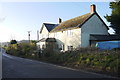
House at Templeman's Ash
Templeman's Ash is a tiny cluster of houses and farm on the B3164 from Broadwindsor west to Brdsmoorgate just west of pilsdon Pen
Image: © Nigel Mykura
Taken: 24 Jan 2015
0.03 miles
2
Sign for Jubilee Trail at Templeman's Ash
Image: © David Smith
Taken: 20 Aug 2019
0.06 miles
4
Signs outside the entrance to Pilsdon Hill Farm
Image: © Rob Purvis
Taken: 3 Sep 2013
0.10 miles
5
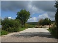
Farm access track, part of Jubilee Trail, Templeman's Ash
Image: © David Smith
Taken: 20 Aug 2019
0.14 miles
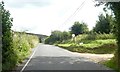
6
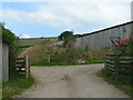
Entrance to Pilsdon Hill Farm, from the B3164
Image: © Rob Purvis
Taken: 3 Sep 2013
0.16 miles
7

Bridleway to Templeman's Ash
The bridleway which is seen crossing fields in Image is seen here climbing the ridge between hedges. Image was taken from the gateway.
Image: © Derek Harper
Taken: 18 Sep 2007
0.19 miles
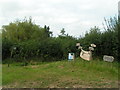
8
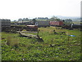
Farm equipment, near Templeman's Ash
Image: © Roger Cornfoot
Taken: 19 Sep 2008
0.19 miles
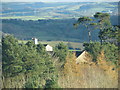
9

Farmland and trees west of Pilsdon Pen
Image: © Maurice D Budden
Taken: 5 Oct 2018
0.25 miles