IMAGES TAKEN NEAR TO
West Bay Fields, BRIDPORT, DT6 5LB
Introduction
This page details the photographs taken nearby to West Bay Fields, DT6 5LB by members of the Geograph project.
The Geograph project started in 2005 with the aim of publishing, organising and preserving representative images for every square kilometre of Great Britain, Ireland and the Isle of Man.

There are currently over 7.5m images from over14,400 individuals and you can help contribute to the project by visiting https://www.geograph.org.uk
Image Map
Images are licensed for reuse under creativecommons.org/licenses/by-sa/2.0
Notes
- Clicking on the map will re-center to the selected point.
- The higher the marker number, the further away the image location is from the centre of the postcode.
Image Listing (62 Images Found)
Images are licensed for reuse under creativecommons.org/licenses/by-sa/2.0
Image
Details
Distance
1
Broomhill Farm
Seen from the Monarch's Way
Image: © N Chadwick
Taken: 30 Dec 2011
0.02 miles
3
A field just north of the A35 site of Seaview Cottages
The cottages were demolished when the A35 was constructed with the loss of a Ordnance Survey cut mark benchmark http://www.bench-marks.org.uk/bm29046
Image: © Roger Templeman
Taken: 21 Sep 2012
0.07 miles
4

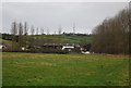
Bridport Waste Management/Recycling Centre
Bridport Waste Management/Recycling Centre, at Broomhills Farm by the A35, was opened on 1st Oct 2015 after 20 years of arguments about possible sites and detailed planning issues. In my view it has been well thought out and is a real success for which the District Council deserve praise. For local context see Image
The A35 is the other side of the trees on the right.
Image: © John Stephen
Taken: 10 Jul 2017
0.07 miles
5
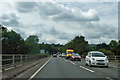
A35 heading west
Leaving Bridport behind.
Image: © Robin Webster
Taken: 18 Jul 2019
0.10 miles
6
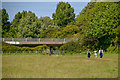
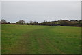
Bridport : Grassy Field
A grassy field and right of way. The bridge carries the A35.
Image: © Lewis Clarke
Taken: 26 May 2020
0.10 miles
7
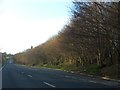
Lay-by on A35 south of Bridport
The road runs through a slight cutting, and the dense woodland on the slope offers further protection for the town from the noise of the traffic.
Image: © David Smith
Taken: 27 Dec 2013
0.10 miles
8
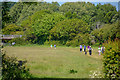
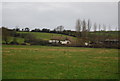
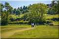
Bridport : Grassy Field
Looking across to people enjoying the right of way through the field.
Image: © Lewis Clarke
Taken: 26 May 2020
0.10 miles
9
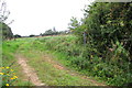
Bridport : Grassy Field
Looking along a field and right of way heading through.
Image: © Lewis Clarke
Taken: 26 May 2020
0.10 miles