IMAGES TAKEN NEAR TO
Filford, BRIDPORT, DT6 5JW
Introduction
This page details the photographs taken nearby to DT6 5JW by members of the Geograph project.
The Geograph project started in 2005 with the aim of publishing, organising and preserving representative images for every square kilometre of Great Britain, Ireland and the Isle of Man.

There are currently over 7.5m images from over14,400 individuals and you can help contribute to the project by visiting https://www.geograph.org.uk
Image Map
Images are licensed for reuse under creativecommons.org/licenses/by-sa/2.0
Notes
- Clicking on the map will re-center to the selected point.
- The higher the marker number, the further away the image location is from the centre of the postcode.
Image Listing (6 Images Found)
Images are licensed for reuse under creativecommons.org/licenses/by-sa/2.0
Image
Details
Distance
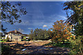
1
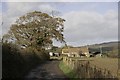
Filford, The End of the Road
This is one of the few houses at this small rural settlement which is at the end of a minor road which descends in to this valley down a steep hill from South Bowood.
Image: © Nigel Mykura
Taken: 4 Oct 2014
0.00 miles
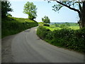
3
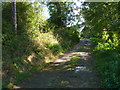
Track to Fowlers Dairy
This is the track that leads from Filford up to Fowler's Dairy. At one time the track ran up to Strongate and then further up the hill to the main road at Salwayash. The track is a bridle path and the track now terminates at Fowler's and no longer exists between there and Strongate but the bridle path still follows the route of the old track, at one point crossing an arable field.
Image: © Nigel Mykura
Taken: 4 Oct 2014
0.05 miles