IMAGES TAKEN NEAR TO
West Allington, BRIDPORT, DT6 5BH
Introduction
This page details the photographs taken nearby to West Allington, DT6 5BH by members of the Geograph project.
The Geograph project started in 2005 with the aim of publishing, organising and preserving representative images for every square kilometre of Great Britain, Ireland and the Isle of Man.

There are currently over 7.5m images from over14,400 individuals and you can help contribute to the project by visiting https://www.geograph.org.uk
Image Map (Loading...)


Getting Data...Please wait
Leaflet Map data © OpenStreetMap
Images are licensed for reuse under creativecommons.org/licenses/by-sa/2.0
Notes
- Clicking on the map will re-center to the selected point.
- The higher the marker number, the further away the image location is from the centre of the postcode.
Image Listing (164 Images Found)
Images are licensed for reuse under creativecommons.org/licenses/by-sa/2.0
Image
Details
Distance
1
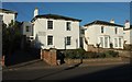
Villas, Bridport
A row of four stucco villas dating from the 1830s on West Allington (the B3162), each of them listed. On the left is a glimpse of Allington Lodge http://www.historicengland.org.uk/listing/the-list/list-entry/1228570 ; then Drayton Lodge http://www.historicengland.org.uk/listing/the-list/list-entry/1279465 ; Avalon http://www.historicengland.org.uk/listing/the-list/list-entry/1228568 and Ivydene http://www.historicengland.org.uk/listing/the-list/list-entry/1228567 .
Image: © Derek Harper
Taken: 31 Oct 2015
0.02 miles
2
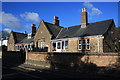
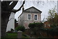
Magdalen Almshouses
These flats were built in 1877 as Almshouses as evidenced by the two plaques which state that and name the churchwardens J A Collins and J G Baker.
Image: © John Stephen
Taken: 18 Jan 2015
0.02 miles
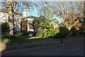
3
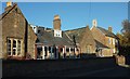
Almshouses, Bridport
The Magdalen Almshouses are shown from the other direction in Image Beyond is the listed number 42 http://www.historicengland.org.uk/listing/the-list/list-entry/1228649 , also shown in Image
Image: © Derek Harper
Taken: 31 Oct 2015
0.02 miles
5
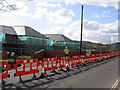
Bridport's new Health Centre
Work continuing on the new health centre in West Road, Bridport.
Image: © Stephen Williams
Taken: 13 Mar 2007
0.05 miles
6
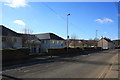
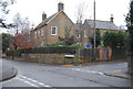
West Allington looking west
View west along West Allington/West Road with the Medical Centre on the left followed by the almost finished Symene Community Land Trust Housing and then West Road Garage.
Image: © John Stephen
Taken: 18 Jan 2015
0.06 miles
7
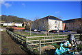
Bridport Medical Centre
Bridport Medical Centre and allotments.
Image: © John Stephen
Taken: 18 Jan 2015
0.07 miles
8
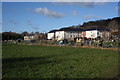
Allotments and Bridport Medical Centre
View of rear of Bridport Medical centre with allotments. On the far left skyline is Colmers Hill. The small housing development middle left is affordable housing for local people and is due to be completed shortly. Allington Hill rises to the right behind the medical centre. The River Simene runs behind the photographer, the field being extremely boggy as a result.
Image: © John Stephen
Taken: 18 Jan 2015
0.07 miles
9
36, West Allington
Grade II listed. http://www.britishlistedbuildings.co.uk/en-403193-34-bridport
Image: © N Chadwick
Taken: 31 Dec 2011
0.07 miles
10
Listed buildings, Bridport
All rather obscured by vegetation. On the left is number 28 West Allington http://www.historicengland.org.uk/listing/the-list/list-entry/1228631 . Next is 26 http://www.historicengland.org.uk/listing/the-list/list-entry/1287114 and the narrower 24 http://www.historicengland.org.uk/listing/the-list/list-entry/1287114 , also shown in Image (as number 36).
Image: © Derek Harper
Taken: 31 Oct 2015
0.07 miles