IMAGES TAKEN NEAR TO
The Paddocks, BRIDPORT, DT6 4SA
Introduction
This page details the photographs taken nearby to The Paddocks, DT6 4SA by members of the Geograph project.
The Geograph project started in 2005 with the aim of publishing, organising and preserving representative images for every square kilometre of Great Britain, Ireland and the Isle of Man.

There are currently over 7.5m images from over14,400 individuals and you can help contribute to the project by visiting https://www.geograph.org.uk
Image Map (Loading...)


Getting Data...Please wait
Leaflet Map data © OpenStreetMap
Images are licensed for reuse under creativecommons.org/licenses/by-sa/2.0
Notes
- Clicking on the map will re-center to the selected point.
- The higher the marker number, the further away the image location is from the centre of the postcode.
Image Listing (58 Images Found)
Images are licensed for reuse under creativecommons.org/licenses/by-sa/2.0
Image
Details
Distance
1
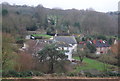
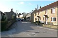
Bothenhampton
On the left is the village church. At the top right is West Bay and just to the left of West Bay is East Cliff. In the foreground is Church Farm
Image: © Nigel Mykura
Taken: 14 Jan 2017
0.02 miles
3

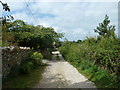
Lesser Celandine on footpath to Bothenhampton
Image: © Becky Williamson
Taken: 31 Mar 2016
0.06 miles
4

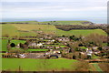
Bothenhampton, Nr Bridport
View from ridge above the village
Image: © Paul Buckingham
Taken: 26 Apr 2004
0.06 miles
6
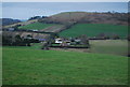
Bothenhampton
A small village on the southern edge of Bridport, this is new build housing on the main street.
Image: © Nigel Mykura
Taken: 15 Mar 2009
0.08 miles
7
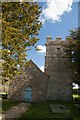
Holy Trinity Church, Bothenhampton
Built in the 14th Century, this delightful church is no longer used as a place of worship, but is preserved beautifully by the Churches Conservation Trust and retains its beauty and peacefulness. There is an Ordnance Survey benchmark on this church which is incredibly difficult to see. For photo, see Image
Image: © Becky Williamson
Taken: 31 Mar 2016
0.08 miles
8
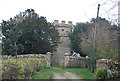
Gate to Old Holy Trinity Church
The gate and walls are Grade II listed. http://www.britishlistedbuildings.co.uk/en-105051-old-holy-trinity-church-bothenhampton
The church is now redundant, Grade I listed. http://www.britishlistedbuildings.co.uk/en-105051-old-holy-trinity-church-bothenhampton
Image: © N Chadwick
Taken: 1 Jan 2012
0.08 miles
9
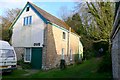
Bothenhampton Mens Club
Bothenhampton Men's Club was originally formed in 1912 in a disused stable elsewhwhere in the village at the top of Duck Street. It then used the newly completed 'Church Hall and Club Room' in 1914. But in 1932 it purchased this building as its own club room. It is a former granary and cider mill at the bottom of Main Street. A first meeting was held there in October 1932, followed by an official opening in November 1932. The club has continued to thrive with male activities such as snooker, billiards, table tennis and darts.
Image: © Nigel Mykura
Taken: 14 Mar 2009
0.08 miles