IMAGES TAKEN NEAR TO
Loders Cross, BRIDPORT, DT6 4PA
Introduction
This page details the photographs taken nearby to DT6 4PA by members of the Geograph project.
The Geograph project started in 2005 with the aim of publishing, organising and preserving representative images for every square kilometre of Great Britain, Ireland and the Isle of Man.

There are currently over 7.5m images from over14,400 individuals and you can help contribute to the project by visiting https://www.geograph.org.uk
Image Map
Images are licensed for reuse under creativecommons.org/licenses/by-sa/2.0
Notes
- Clicking on the map will re-center to the selected point.
- The higher the marker number, the further away the image location is from the centre of the postcode.
Image Listing (18 Images Found)
Images are licensed for reuse under creativecommons.org/licenses/by-sa/2.0
Image
Details
Distance
1
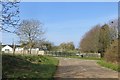
The old A35
A previous alignment is now in use as a yellow road. Here it is joining Shipton Lane which passes under the new A35 by a bridge through an embankment.
Image: © Richard Webb
Taken: 8 Apr 2015
0.04 miles
2
Shipton Lane at A35 underpass near Gribb Farm
It is suggested that this is the site of a wall on which an Ordnance Survey cut mark benchmark, http://www.bench-marks.org.uk/bm29082 , was cut in 1850 as a mark on the Exeter to Southampton 1GL levelling line
Image: © Roger Templeman
Taken: 19 Sep 2012
0.06 miles
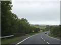
3

A35 heading west
Dorchester Road towards Bridport.
Image: © Robin Webster
Taken: 18 Jul 2019
0.06 miles
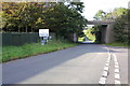
4
A35 bridge over Shipton Lane
The bridge has railings which interrupt the crash barriers.
Image: © David Smith
Taken: 16 Jun 2012
0.06 miles
5
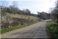
A35 embankment
The new alignment of the road, above its predecessor.
Image: © Richard Webb
Taken: 8 Apr 2015
0.07 miles
6
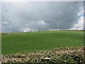
Field and black sky
Field and an increasingly darkening sky near Loders, Dorset.
Taken from Shipton Lane.
Image: © T Eyre
Taken: 12 Apr 2012
0.10 miles
7
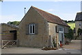
Barn conversion at Higher Uploders Farm
There is an OS benchmark Image on the front right corner of the building
Image: © Roger Templeman
Taken: 19 Sep 2012
0.11 miles
8
Benchmark on converted barn at Higher Uploders Farm
Ordnance Survey cut mark benchmark described on the Bench Mark Database at http://www.bench-marks.org.uk/bm45529
Image: © Roger Templeman
Taken: 19 Sep 2012
0.12 miles
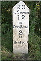
9
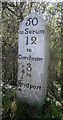
Old Milestone by the A35, west of Vinney Cross
Carved stone post by the A35, in parish of LODERS (WEST DORSET District), South of Uploders, on A35 300m from Uploders turnoff. By start of Armco Barrier, on South side of road. Dorset 1 (limestone), erected by the Harnham, Blandford & Dorchester turnpike trust in the 19th century.
Inscription reads:-
50
to Sarum
12
to
Dorchester
3
to
Bridport
Milestone Society National ID: DO_BPDO03.
Image: © Mike Richards
Taken: 22 Aug 2002
0.14 miles
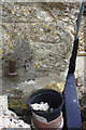
10
Milestone on south side of A35
There was an Ordnance Survey cut mark benchmark between 'Bridport' and the ground which has been chiselled off. The mark is described on the Bench Mark Database at http://www.bench-marks.org.uk/bm28991
Image: © Roger Templeman
Taken: 19 Sep 2012
0.14 miles