IMAGES TAKEN NEAR TO
Wanderwell Farm Lane, BRIDPORT, DT6 4JW
Introduction
This page details the photographs taken nearby to Wanderwell Farm Lane, DT6 4JW by members of the Geograph project.
The Geograph project started in 2005 with the aim of publishing, organising and preserving representative images for every square kilometre of Great Britain, Ireland and the Isle of Man.

There are currently over 7.5m images from over14,400 individuals and you can help contribute to the project by visiting https://www.geograph.org.uk
Image Map (Loading...)


Getting Data...Please wait
Leaflet Map data © OpenStreetMap
Images are licensed for reuse under creativecommons.org/licenses/by-sa/2.0
Notes
- Clicking on the map will re-center to the selected point.
- The higher the marker number, the further away the image location is from the centre of the postcode.
Image Listing (107 Images Found)
Images are licensed for reuse under creativecommons.org/licenses/by-sa/2.0
Image
Details
Distance
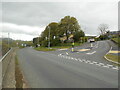
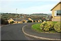
1
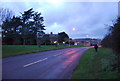
North Hill Way meets Chestnut Road, Bridport
An estate near Bothenhampton. In the background is Bridport.
Image: © Derek Harper
Taken: 1 Nov 2017
0.04 miles
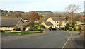
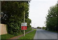
3
Chestnut Road, Bridport
The road shown at the rear of Image], passing the start of footpath W5 18 on the right as it drops to a small side valley of the Brit.
Image: © Derek Harper
Taken: 1 Nov 2017
0.06 miles
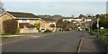
4
Chestnut road
The Chestnut tree in this case is still in place.
Whilst not obvious the grass verges have not been cut. Being 'No mow May'
A project designed to help pollinators.
Image: © Anthony Vosper
Taken: 18 May 2021
0.07 miles
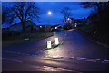
6
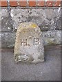
Old Boundary Marker by the B3157, Burton Road, Bridport
Parish Boundary Marker by the B3157, in parish of Bridport (West Dorset District), Burton Road, 100m South of roundabout, against wall in sunken pavement.
Inscription reads:-
H B
Surveyed
Milestone Society National ID: DO_BRID01pb
Image: © Milestone Society
Taken: Unknown
0.07 miles
7
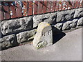
Boundary Stone Burton Rd
This small stone which appears to be made from Portland Stone and has been damaged and patched with cement mortar is on the outside of a low garden wall on the pavement.
Image: © Nigel Mykura
Taken: 16 Mar 2014
0.07 miles
8
North Hill Way, Bridport
A cul-de-sac with good views to Bridport. See also Image
Image: © Derek Harper
Taken: 1 Nov 2017
0.08 miles
9
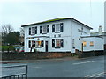
The Crown Inn
On West Bay Road, facing the A35 roundabout.
Image: © Jonathan Billinger
Taken: 8 Dec 2009
0.09 miles