IMAGES TAKEN NEAR TO
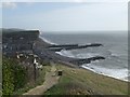
First Cliff Walk, BRIDPORT, DT6 4HH
Introduction
This page details the photographs taken nearby to First Cliff Walk, DT6 4HH by members of the Geograph project.
The Geograph project started in 2005 with the aim of publishing, organising and preserving representative images for every square kilometre of Great Britain, Ireland and the Isle of Man.

There are currently over 7.5m images from over14,400 individuals and you can help contribute to the project by visiting https://www.geograph.org.uk
Image Map
Images are licensed for reuse under creativecommons.org/licenses/by-sa/2.0
Notes
- Clicking on the map will re-center to the selected point.
- The higher the marker number, the further away the image location is from the centre of the postcode.
Image Listing (296 Images Found)
Images are licensed for reuse under creativecommons.org/licenses/by-sa/2.0
Image
Details
Distance
1
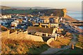
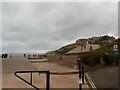
View of West Bay from the coastal path
Image: © Mr Eugene Birchall
Taken: 19 Jan 2011
0.02 miles
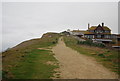
2
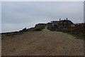
The Monarch's Way/South West Coastal Path
The path seen here climbing West Cliff.
Image: © John Lucas
Taken: 29 Nov 2019
0.03 miles
3
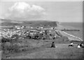
West Bay from West Cliff, c.1958
Taken by my late mother Eileen Warren in approximately 1958 - sorry I can't be more precise with the date.
Also see Image] taken at the same time.
Image: © Eileen Warren
Taken: Unknown
0.03 miles
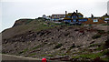
5
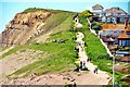
Western end of West Bay Esplanade
The South West Coast Path on the way up West Cliff
Image: © Eirian Evans
Taken: 28 Oct 2021
0.04 miles
6
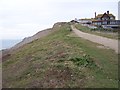
The Coastal Path heading West from West Bay
This is the South West Coast Path heading West out of West Bay towards West Cliff - that is a lot of Wests!
Image: © Chris Heaton
Taken: 26 Jan 2017
0.04 miles
7
West Bay: Coastal path leading westwards
Image: © Mr Eugene Birchall
Taken: 12 May 2012
0.04 miles
8

The South West Coast Path descending to West Bay
Image: © N Chadwick
Taken: 30 Dec 2011
0.04 miles
9
Path ascending West Cliff from West Bay
Image: © David Martin
Taken: 14 Feb 2012
0.04 miles
10
Monarch's Way at West Bay
The southernmost point on the Monarch's Way.
After failing to find a passage here the King Charles II headed inland before trying again much further along the coast at Shoreham.
Image: © John M
Taken: 26 Feb 2008
0.04 miles