IMAGES TAKEN NEAR TO
Sunnyside, Main Street, BRIDPORT, DT6 4BL
Introduction
This page details the photographs taken nearby to Sunnyside, Main Street, DT6 4BL by members of the Geograph project.
The Geograph project started in 2005 with the aim of publishing, organising and preserving representative images for every square kilometre of Great Britain, Ireland and the Isle of Man.

There are currently over 7.5m images from over14,400 individuals and you can help contribute to the project by visiting https://www.geograph.org.uk
Image Map
Images are licensed for reuse under creativecommons.org/licenses/by-sa/2.0
Notes
- Clicking on the map will re-center to the selected point.
- The higher the marker number, the further away the image location is from the centre of the postcode.
Image Listing (94 Images Found)
Images are licensed for reuse under creativecommons.org/licenses/by-sa/2.0
Image
Details
Distance
1
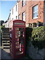
Bothenhampton: west along Main Street
The main carriageway is out of picture to the right, while we look past the telephone box and up the steps to the Main Street pavement.
Image: © Chris Downer
Taken: 12 Sep 2009
0.04 miles
2
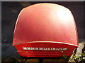
Bothenhampton: phone-box roof
An unusual perspective of a telephone box! The reason it is possible here is simply explained by looking at it here: Image
Image: © Chris Downer
Taken: 12 Sep 2009
0.04 miles
3
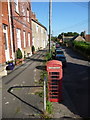
Bothenhampton: east along Main Street
Looking along Main Street from the top of the steps that provide access to the road from the elevated northern pavement.
Image: © Chris Downer
Taken: 12 Sep 2009
0.04 miles
4
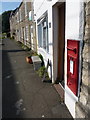
Bothenhampton: postbox № DT6 27 and the old post office
The post office and village stores here closed on 11 September 2003, only four years short of its hundredth anniversary of serving the village. The Elizabeth II-reign postbox is emptied finally at 4pm on weekdays and at noon on Saturdays.
Image: © Chris Downer
Taken: 12 Sep 2009
0.05 miles
5
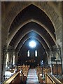
Inside Holy Trinity New Church, Bothenhampton (i)
Image: © Basher Eyre
Taken: 3 Sep 2013
0.09 miles
6
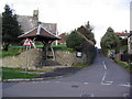
Crock Lane, Bridport
The Church porch at the south end of Crock Lane where it meets Hollow Way and Main Street, Bothenhampton.
Image: © Stephen Williams
Taken: 25 Feb 2007
0.09 miles
7
Inside Holy Trinity New Church, Bothenhampton (g)
Image: © Basher Eyre
Taken: 3 Sep 2013
0.09 miles
8
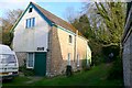
Bothenhampton Mens Club
Bothenhampton Men's Club was originally formed in 1912 in a disused stable elsewhwhere in the village at the top of Duck Street. It then used the newly completed 'Church Hall and Club Room' in 1914. But in 1932 it purchased this building as its own club room. It is a former granary and cider mill at the bottom of Main Street. A first meeting was held there in October 1932, followed by an official opening in November 1932. The club has continued to thrive with male activities such as snooker, billiards, table tennis and darts.
Image: © Nigel Mykura
Taken: 14 Mar 2009
0.10 miles
9
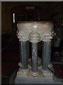
Holy Trinity New Church, Bothenhampton: font
Image: © Basher Eyre
Taken: 3 Sep 2013
0.10 miles
10
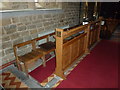
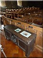
Holy Trinity New Church, Bothenhampton: choir stalls
Image: © Basher Eyre
Taken: 3 Sep 2013
0.10 miles