IMAGES TAKEN NEAR TO
East Road, BRIDPORT, DT6 4AF
Introduction
This page details the photographs taken nearby to East Road, DT6 4AF by members of the Geograph project.
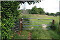
The Geograph project started in 2005 with the aim of publishing, organising and preserving representative images for every square kilometre of Great Britain, Ireland and the Isle of Man.

There are currently over 7.5m images from over14,400 individuals and you can help contribute to the project by visiting https://www.geograph.org.uk
Image Map
Images are licensed for reuse under creativecommons.org/licenses/by-sa/2.0
Notes
- Clicking on the map will re-center to the selected point.
- The higher the marker number, the further away the image location is from the centre of the postcode.
Image Listing (121 Images Found)
Images are licensed for reuse under creativecommons.org/licenses/by-sa/2.0
Image
Details
Distance
1
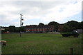
Behind East Road
View SW from footpath to Jessopp's Weir towards the backs of houses on East Road. The forlorn looking truck in the field is an ex forces 1950s vintage Bedford RL.
Image: © John Stephen
Taken: 28 Jun 2013
0.02 miles
2
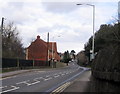
A35 East Road in Bridport looking East
This is a view ENE from the end of Crock Lane, looking up the A35. At the bus stop can sometimes be found a bus to Dorchester. The red brick buildings are a new housing development on the site of the old Toll House pub.
Image: © Stephen Williams
Taken: 25 Feb 2007
0.03 miles
3
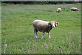
Footpath enforcement officer
This somewhat belligerent looking ram in the field next to the footpath to Jessopp's Weir. The fence was barbed and the gate chained and marked Private so there was no chance of a confrontation.
Image: © John Stephen
Taken: 28 Jun 2013
0.04 miles
4
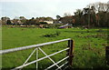
Sheep near Bridport
From footpath W1 12 looking across what is in effect an island formed by two branches of the River Asker. The houses are across the southern arm on the A35 East Road.
Image: © Derek Harper
Taken: 1 Nov 2017
0.04 miles
5
Footpath towards Jessopp Weir
The footpath from Asker Mill Barn on the north side of the A35 towards Jessopp Weir across the millstream turns abruptly left here through the small gate and is shoulder high in foliage.
Image: © John Stephen
Taken: 28 Jun 2013
0.04 miles
6
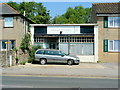
Hair today, gone tomorrow
Both shop and car are well past their prime in this view across the A35 east of Bridport.
Image: © Jonathan Billinger
Taken: 4 Jun 2010
0.05 miles
7
House on East Road
East Road is behind the house in this view. It face south onto the small lane that links Crock Lane and Walditch Rd.
Image: © Nigel Mykura
Taken: 3 Aug 2016
0.05 miles
8
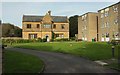
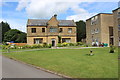
Battlecombe
The house in the centre is listed and described at https://www.historicengland.org.uk/listing/the-list/list-entry/1118995 . "Rear has mullioned windows and 2 storey projecting porch block, with canted lower section surmounted by a gable on moulded squinches". Now converted into three flats. On the right is Hanover Court. Seen from the Monarch's Way.
Image: © Derek Harper
Taken: 1 Nov 2017
0.05 miles
9
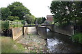
Jessopp's Weir and fish pass
Jessopp's Weir on the River Asker. The fish pass (on the right with steps) was installed in 2010. It also has a side channel on the extreme left, to allow passage of eels. Fish (sea trout) have been photographed passing upstream, so it does work. The weir on the Brit at Palmers Brewery also has a fish pass. The weir also has a gauging station (the brick built hut) and forms part of the flood management scheme for the Rivers Asker and Brit.
Image: © John Stephen
Taken: 26 Jun 2013
0.06 miles
10
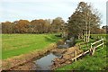
River Asker
Footpath W1 12 runs beside the river and crosses a footbridge at Jessopps weir seen upstream, just into Image
Image: © Derek Harper
Taken: 1 Nov 2017
0.06 miles