IMAGES TAKEN NEAR TO
South Walk, BRIDPORT, DT6 3XB
Introduction
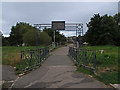
This page details the photographs taken nearby to South Walk, DT6 3XB by members of the Geograph project.
The Geograph project started in 2005 with the aim of publishing, organising and preserving representative images for every square kilometre of Great Britain, Ireland and the Isle of Man.

There are currently over 7.5m images from over14,400 individuals and you can help contribute to the project by visiting https://www.geograph.org.uk
Image Map
Images are licensed for reuse under creativecommons.org/licenses/by-sa/2.0
Notes
- Clicking on the map will re-center to the selected point.
- The higher the marker number, the further away the image location is from the centre of the postcode.
Image Listing (556 Images Found)
Images are licensed for reuse under creativecommons.org/licenses/by-sa/2.0
Image
Details
Distance
1
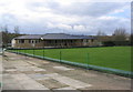
Bridport Bowling Club and green
The new pavilion at Bridport Bowling Club, off Priory Lane.
Image: © Stephen Williams
Taken: 25 Feb 2007
0.01 miles
2
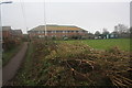
Priory Lane and Bowling Green
View along Priory Lane showing recently severely pruned and laid hedge both sides of the lane. You couldn't see over the hedges and banks in either direction before this was done and were full of wildflowers in the summer. See Image
Image: © John Stephen
Taken: 8 Jan 2013
0.01 miles
3
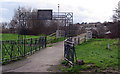
St. Mary's bridge, over the River Brit, Bridport
This is a lovely wooden footbridge over the River Brit, between Priory Lane and St. Mary's playing field in Bridport. It saves a long walk via either the Dreadnought trading estate or Skilling Hill Road. The sign says:
"Erected by public submission to commemorate the coronation of King George VI and Queen Elizabeth. May 12 1937. H.R.C. Palmer, Mayor".
Image: © Stephen Williams
Taken: 25 Feb 2007
0.02 miles
7
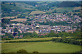
Symondsbury : Bridport Scenery
Looking down into Bridport from the surrounding hills.
Image: © Lewis Clarke
Taken: 26 May 2020
0.03 miles
8
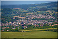
Symondsbury : Bridport Scenery
Looking down into the town of Bridport.
Image: © Lewis Clarke
Taken: 26 May 2020
0.03 miles
10
Decimated Hedge
The drastically cropped hedge at the bowling green end of Priory Lane. It has been cut back both on the bowling green side and the community orchard side. Admittedly an attempt has been made to lay it, but it was about 8 feet high and a glorious mix of wild flowers in the summer. Seems a bit heavy handed to me. See Image
Image: © John Stephen
Taken: 8 Jan 2013
0.03 miles