IMAGES TAKEN NEAR TO
West Milton, BRIDPORT, DT6 3TN
Introduction
This page details the photographs taken nearby to DT6 3TN by members of the Geograph project.
The Geograph project started in 2005 with the aim of publishing, organising and preserving representative images for every square kilometre of Great Britain, Ireland and the Isle of Man.

There are currently over 7.5m images from over14,400 individuals and you can help contribute to the project by visiting https://www.geograph.org.uk
Image Map (Loading...)


Getting Data...Please wait
Leaflet Map data © OpenStreetMap
Images are licensed for reuse under creativecommons.org/licenses/by-sa/2.0
Notes
- Clicking on the map will re-center to the selected point.
- The higher the marker number, the further away the image location is from the centre of the postcode.
Image Listing (13 Images Found)
Images are licensed for reuse under creativecommons.org/licenses/by-sa/2.0
Image
Details
Distance
1
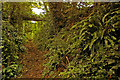
Sunken bridleway
Looking up the bridleway leading from Leigh Gate to Lancombe House
Image: © Ian Capper
Taken: 12 Jul 2008
0.06 miles
2
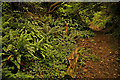
Sunken bridleway
Looking down the bridleway leading from Lancombe House to Leigh Gate, lined with ferns.
Image: © Ian Capper
Taken: 12 Jul 2008
0.10 miles
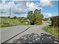
3
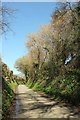
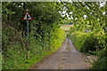
Lane to Lancombes Cross
Climbing a valley from West Milton; once beyond the junction, it becomes Ridgeback Lane.
Image: © Derek Harper
Taken: 13 Mar 2017
0.10 miles
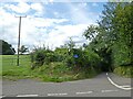
4
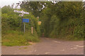
Lane to Loscombe
This is the south end of the lane in Image It's not just the narrow width of the road that's the problem for HGVs (or indeed any vehicle) - there's also the lack of passing places for long stretches, due to the sunken nature of the lane for much of its length (see Image for example).
Image: © Ian Capper
Taken: 18 Jul 2008
0.13 miles
5
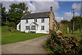
Marlpits Farm
Old maps show quarries nearby, presumably the marlpits referred to in the farm name.
Image: © Ian Capper
Taken: 13 Jul 2008
0.14 miles
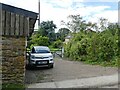
7
Loscombe, crossroads
Coming from the bridleway, left to West Milton, ahead to the hamlet centre, right to Poorton.
Image: © Mike Faherty
Taken: 19 Oct 2016
0.14 miles
9
Ridgeback Lane
The sign is for the lane leading down to Loscombe (see Image).
Image: © Ian Capper
Taken: 12 Jul 2008
0.17 miles
10
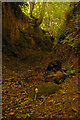
Sunken track
This deeply sunken track (the cutting sides are at least 15 ft high), marked on the map as an "other route with public access", leads from above West Milton to Ridgeback Lane. In the foreground is a Shaggy Ink Cap (Coprinus comatus), whose cap just a couple of days later had disintegrated into a soggy mess.
Image: © Ian Capper
Taken: 12 Jul 2008
0.19 miles