IMAGES TAKEN NEAR TO
Church Street, BRIDPORT, DT6 3PS
Introduction
This page details the photographs taken nearby to Church Street, DT6 3PS by members of the Geograph project.
The Geograph project started in 2005 with the aim of publishing, organising and preserving representative images for every square kilometre of Great Britain, Ireland and the Isle of Man.

There are currently over 7.5m images from over14,400 individuals and you can help contribute to the project by visiting https://www.geograph.org.uk
Image Map
Images are licensed for reuse under creativecommons.org/licenses/by-sa/2.0
Notes
- Clicking on the map will re-center to the selected point.
- The higher the marker number, the further away the image location is from the centre of the postcode.
Image Listing (771 Images Found)
Images are licensed for reuse under creativecommons.org/licenses/by-sa/2.0
Image
Details
Distance
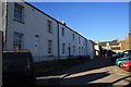
1
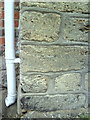
Benchmark on #15 Church Street
The Ordnance Survey cut mark benchmark (the horizontal height cut at top left of photo) is described on the Bench Mark Database at http://www.bench-marks.org.uk/bm25157
Image: © Roger Templeman
Taken: 23 Sep 2010
0.00 miles
2
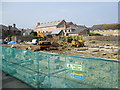
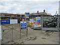
Redevelopment of 45 South Street and land off Church Street
45 South Street (The Citizens Advice Bureau) and the ex Wessex Water depot behind (off Church Street) are being redeveloped by WW to provide new flats and houses with associated parking and access. For a change it does include affordable housing.
Image: © John Stephen
Taken: 27 Mar 2017
0.01 miles
3
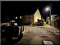
Private Road, Bridport
An old tractor quietly parked up in the back streets of Bridport. New Zealand Terrace, a newbuild street ahead, is private.
Image: © Mike Parker
Taken: 19 Mar 2023
0.01 miles
4
Church Place development, Church Street
45 South Street (The Citizens Advice Bureau) and the ex Wessex Water depot behind (off Church Street) are being redeveloped by WW to provide new flats and houses with associated parking and access. For a change it does include affordable housing.
Image: © John Stephen
Taken: 13 Aug 2017
0.01 miles
5
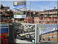
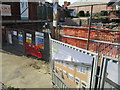
Church Place development, Church Street
3 Bed £K324.95. 2 Bed £279950, £K244 EOT. Plot of 11 houses and 3 affordable units. Was Wessex Water yard. Nice to see some affordable housing being built in the renovated extension to the South Street property, by Nest Homes
Image: © John Stephen
Taken: 28 May 2018
0.02 miles
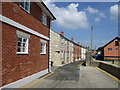
6
Church Street
View along Church Street from its junction with South Mill Lane. Church street turns through 90 degrees here from roughly west-east around the corner of the house on the extreme left edge to south-north along this terrace. Running across at the end of the road is Folly Mill Lane. South Mill Lane is behind the camera.
Image: © John Stephen
Taken: 14 Oct 2012
0.02 miles
7
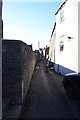
Church Street
View west along Church Street. The steps on the left lead into South Street car park. Church Street comes down from South Street in the distance and turns 90 degrees to the right around the end of the white painted house towards Folly Mill Lane.
Image: © John Stephen
Taken: 14 Oct 2012
0.02 miles
8
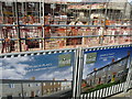
Church Place development, Church Street, artist's impressions
45 South Street (The Citizens Advice Bureau) and the ex Wessex Water depot behind (off Church Street) are being redeveloped by WW to provide new flats and houses with associated parking and access. For a change it does include affordable housing.
Image: © John Stephen
Taken: 13 Aug 2017
0.02 miles
9
Church Place development, Church Street
45 South Street (The Citizens Advice Bureau) and the ex Wessex Water depot behind (off Church Street) are being redeveloped by WW to provide new flats and houses with associated parking and access. For a change it does include affordable housing.
Image: © John Stephen
Taken: 27 Jul 2017
0.02 miles
10
Church Place development, Church Street
45 South Street (The Citizens Advice Bureau) and the ex Wessex Water depot behind (off Church Street) are being redeveloped by WW to provide new flats and houses with associated parking and access. For a change it does include affordable housing.
Image: © John Stephen
Taken: 13 Aug 2017
0.02 miles