IMAGES TAKEN NEAR TO
South Street, BRIDPORT, DT6 3PD
Introduction
This page details the photographs taken nearby to South Street, DT6 3PD by members of the Geograph project.
The Geograph project started in 2005 with the aim of publishing, organising and preserving representative images for every square kilometre of Great Britain, Ireland and the Isle of Man.

There are currently over 7.5m images from over14,400 individuals and you can help contribute to the project by visiting https://www.geograph.org.uk
Image Map
Images are licensed for reuse under creativecommons.org/licenses/by-sa/2.0
Notes
- Clicking on the map will re-center to the selected point.
- The higher the marker number, the further away the image location is from the centre of the postcode.
Image Listing (393 Images Found)
Images are licensed for reuse under creativecommons.org/licenses/by-sa/2.0
Image
Details
Distance
1
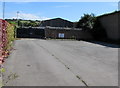
Empty car park on the east side of South Street, Bridport
Viewed in August 2017. The notice on the wall in the background shows
THIS CAR PARK IS FOR THE USERS OF THE BRIDPORT DAY CENTRE ONLY.
The car park is on the south side of Fishermans Arms Day Centre https://www.geograph.org.uk/photo/5873350 which had closed down at the July 2018 date of this https://www.geograph.org.uk/photo/5851440 photo.
Image: © Jaggery
Taken: 25 Aug 2017
0.01 miles
2
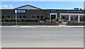
Jewson, Bridport
On the east side of South Street.
Image: © Jaggery
Taken: 25 Aug 2017
0.02 miles
3
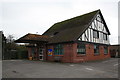
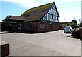
The Fisherman's Arms day centre
The Fisherman's Arms is a local authority run day centre for people with learning disabilities. It was a pub, hence the name.
Image: © John Stephen
Taken: 21 Oct 2012
0.03 miles
4
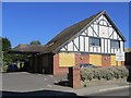
Fishermans Arms Day Centre, South Street, Bridport
Viewed in August 2017. The name sign on the left shows that the day centre is part of Dorset County Council's Social Services Directorate. This later photo https://www.geograph.org.uk/photo/5851440 taken in July 2018 shows that the day centre has closed down.
The Closed Pubs website records that the building was erected in the 1930s as the Fishermans Arms pub. Planning permission for change of use was granted to Palmers Brewery in January 1998.
Image: © Jaggery
Taken: 25 Aug 2017
0.03 miles
5
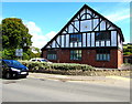
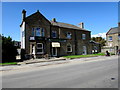
Fisherman's Arms, boarded up
The Fishermans Arms is a former public house in South Street. Planning permission for change of use was granted to Palmers Brewery in January 1998 and it was then used as a County Council day centre for people with learning disabilities until budget cuts saw its closure last year.
The tiled sign by the door, a relic from its Pub days, has been removed (see Image ).
There was talk of the site being redeveloped as a Social Services centre for adult services by 2019, but the County Council is becoming a unitary authority next year and budget cuts continue, so I wouldn't bet on it.
Image: © John Stephen
Taken: 22 Jul 2018
0.03 miles
6
Fishermans Arms Day Centre in Bridport
Viewed in August 2017 when the building was in use as Fishermans Arms Day Centre, part of Dorset County Council's Social Services Directorate. A photo https://www.geograph.org.uk/photo/5851440 taken in July 2018 shows that the day centre has closed down.
The Closed Pubs website records that the building was erected in the 1930s as the Fishermans Arms pub. Planning permission for change of use was granted to Palmers Brewery in January 1998.
Image: © Jaggery
Taken: 25 Aug 2017
0.03 miles
7
Coriander, Bridport
Indian cuisine restaurant and takeaway viewed across South Street.
Image: © Jaggery
Taken: 25 Aug 2017
0.04 miles
8
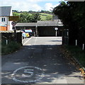
5mph speed limit on the entrance road to Dorset Highways Bridport Depot
On the east side of South Street. A sign https://www.geograph.org.uk/photo/5873329 near the camera shows No Public Access.
Image: © Jaggery
Taken: 25 Aug 2017
0.04 miles
9
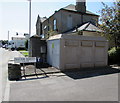
Western Power Distribution electricity substation on a Bridport corner
On the corner of South Street and Doctor Roberts Close.
The substation identifier is SOUTH STREET 251350.
Image: © Jaggery
Taken: 25 Aug 2017
0.04 miles
10
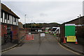
Bridport household waste recycling centre
South Street recycling centre past the black gates. The restricted access from South Street creates traffic chaos at times, however discussions about alternative sites for the recycling facility seem to be interminable.
Immediately behind the wooden gates is the parking used by local authority transport for the disabled, there being training facilities for the disabled nearby, for example the Fisherman's Arms day centre (the building on the left),Flood Lane and the Mountjoy School further down the road.
Image: © John Stephen
Taken: 21 Oct 2012
0.04 miles