1
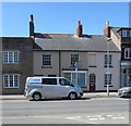
U-Drive van, South Street, Bridport
The rental van is parked opposite the Church Street junction.
The black arrow on the sign showing All routes (A35) points left (south) along the B3157 South Street.
Image: © Jaggery
Taken: 25 Aug 2017
0.02 miles
2
South Street Almshouse
Grade II listed. http://www.britishlistedbuildings.co.uk/en-402926-almshouses-64-bridport
Image: © N Chadwick
Taken: 28 Dec 2011
0.02 miles
3
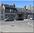
Chantelle, Bridport
Chantelle hair stylist at 60 South Street viewed from the corner of Church Street.
Image: © Jaggery
Taken: 25 Aug 2017
0.02 miles
4
Land behind Oxenbury's and Assembly Rooms Gundry Lane
This land behind Oxenbury's and The Assembly Rooms is subject of a proposal by Palmers Brewery to build nine houses.
Image: © John Stephen
Taken: 28 Dec 2017
0.03 miles
5
Bridport town
A general view of one of the main streets in Bridport. On the right are market and table top stalls whilst in the distance can be seen the clock on one of the local authority buildings.
Image: © Mike Crowe
Taken: 18 Jun 2005
0.03 miles
6
Hamilton Place
Grade II listed. http://www.britishlistedbuildings.co.uk/en-402931-hamilton-place-72-and-74-bridport
Image: © N Chadwick
Taken: 28 Dec 2011
0.03 miles
7
46, South St
Grade II listed. http://www.britishlistedbuildings.co.uk/en-402919-46-and-48-bridport
Image: © N Chadwick
Taken: 28 Dec 2011
0.03 miles
8
Sundorbon Tandoori, Bridport
Indian cuisine restaurant and takeaway at 68 South Street.
The premises of A.G.Down funeral directors & monumental masons at 66 South Street are on the right.
Image: © Jaggery
Taken: 25 Aug 2017
0.03 miles
9
Fire and Rescue vehicles standing by in South Street
Fire broke out in Tower Building on St Michael's Trading Estate on Saturday evening. It started in the artists studios area and is thought to have been either an electrical fault or generated by sunlight on flammable materials. 12 Fire appliances, including two aerial ladders and a water tanker attended from all over Dorset and East Devon. The estate has plans for redevelopment, but this building was not due to be replaced.
Image: © John Stephen
Taken: 7 Jul 2018
0.03 miles
10
Land behind Oxenbury's and Assembly Rooms, Gundry Lane
This land behind Oxenbury's and The Assembly Rooms is subject of a proposal by Palmers Brewery to build nine houses.
Image: © John Stephen
Taken: 28 Dec 2017
0.03 miles


