IMAGES TAKEN NEAR TO
St. Andrews Road, BRIDPORT, DT6 3HB
Introduction
This page details the photographs taken nearby to St. Andrews Road, DT6 3HB by members of the Geograph project.
The Geograph project started in 2005 with the aim of publishing, organising and preserving representative images for every square kilometre of Great Britain, Ireland and the Isle of Man.

There are currently over 7.5m images from over14,400 individuals and you can help contribute to the project by visiting https://www.geograph.org.uk
Image Map
Images are licensed for reuse under creativecommons.org/licenses/by-sa/2.0
Notes
- Clicking on the map will re-center to the selected point.
- The higher the marker number, the further away the image location is from the centre of the postcode.
Image Listing (245 Images Found)
Images are licensed for reuse under creativecommons.org/licenses/by-sa/2.0
Image
Details
Distance
1
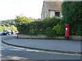
Bridport: postbox № DT6 31, Barrack Street
This Elizabeth II-reign postbox, on the Nursery Gardens junction, is emptied finally at 5:15pm on weekdays and at noon on Saturdays.
Image: © Chris Downer
Taken: 12 Sep 2009
0.03 miles
2
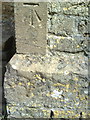
Benchmark on former St Andrews Church
Ordnance Survey cut mark benchmark described on the Bench Mark Database at http://www.bench-marks.org.uk/bm25019
Image: © Roger Templeman
Taken: 23 Sep 2010
0.06 miles
3
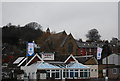
St Andrew's Church
Grade II listed. http://www.britishlistedbuildings.co.uk/en-401852-st-andrew-s-church-bridport
Image: © N Chadwick
Taken: 31 Dec 2011
0.06 miles
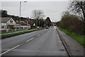
4
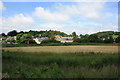
Bridport from the east
View of Bridport from the east behind the A35. The point of view is in SY4792 on the east bank of the River Asker, the buildings and Sea Road North (the A3066 to Beaminster) are in SY4793. The low buildings in the middle distance are on the Old Laundry industrial estate on the west side of Sea Road North (which runs left to right). In the centre is the rear of St Andrew's Church, which fronts onto on St Andrews Road. Coneygar Hill is on the left and Watton Hill on the right.
Image: © John Stephen
Taken: 28 Jun 2013
0.08 miles
5

Port Bredy
Grade II listed, former Workhouse. http://www.britishlistedbuildings.co.uk/en-104474-port-bredy-hospital-bridport
Image: © N Chadwick
Taken: 1 Jan 2012
0.09 miles
6
Bridport Union Workhouse
The union was formed in 1836 and consisted of 19 Dorset parishes;-
Allington (2), Askerswell, Bothenhampton, Bradpole (2), Bridport (4), Burton Bradstock (2), Catherston Leweston, Chideock, Chilcombe, Litton Cheney, Loders, Stratton St Gabriel, Swyre, Symondsbury (2), Walditch, Whitechurch Canonicorum (2), Wootton Fitzpaine.
The workhouse was built to accommodate 200 inmates at the junction of Barrack Street and Bedford Place. Designed by Henry J Whitling, the three-storey building was constructed from local stone. It followed the popular cruciform plan which created yards for the different categories of inmate. After being converted to a hospital it was recently converted to residential use.
Image: © Nigel Mykura
Taken: 1 Oct 2011
0.10 miles
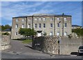
7

Port Bredy Hospital, Bridport
The suitably austere looking former workhouse from ca. 1836 later because the town infirmary and closed as recently as 1996; now converted to "executive" flats. Grade-II listed (ref. 1119024): https://www.britishlistedbuildings.co.uk/101119024-port-bredy-hospital-bridport#.WhdAzCZLGAg .
Image: © Bill Harrison
Taken: 9 Jul 2016
0.10 miles
8
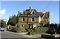
Victorian housing in St. Andrew's Rd, Bridport
This fine pair of houses, and a similar pair out of view to the right, were designed by the firm of architects for whom Thomas Hardy was apprenticed, and it is thought that he designed some details of the houses. The houses are now largely sub-divided into flats.
Image: © Stephen Williams
Taken: 6 Mar 2007
0.11 miles
9
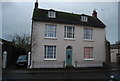
26, Barrack St
Grade II listed. http://www.britishlistedbuildings.co.uk/en-104461-26-bridport
Image: © N Chadwick
Taken: 1 Jan 2012
0.11 miles