IMAGES TAKEN NEAR TO
Fortuneswell, PORTLAND, DT5 1LR
Introduction
This page details the photographs taken nearby to Fortuneswell, DT5 1LR by members of the Geograph project.
The Geograph project started in 2005 with the aim of publishing, organising and preserving representative images for every square kilometre of Great Britain, Ireland and the Isle of Man.

There are currently over 7.5m images from over14,400 individuals and you can help contribute to the project by visiting https://www.geograph.org.uk
Image Map
Images are licensed for reuse under creativecommons.org/licenses/by-sa/2.0
Notes
- Clicking on the map will re-center to the selected point.
- The higher the marker number, the further away the image location is from the centre of the postcode.
Image Listing (256 Images Found)
Images are licensed for reuse under creativecommons.org/licenses/by-sa/2.0
Image
Details
Distance
2
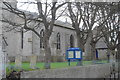
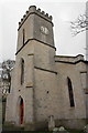
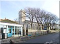
St John the Baptist, Fortuneswell: tower
Image: © Basher Eyre
Taken: 4 Sep 2012
0.01 miles
3
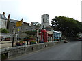
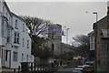
Fortuneswell Church
View of Portland's largest village from The Heights.
http://en.wikipedia.org/wiki/Isle_of_Portland
Image: © Colin Smith
Taken: 14 Jan 2012
0.01 miles
4
Dreamy days in Dorset 41: Fortuneswell
The church you can see behind the phone box and launderette is St John the Baptist, built in 1839.
Image: © Basher Eyre
Taken: 4 Sep 2012
0.01 miles
5
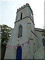
Church of St John
Grade II listed. https://historicengland.org.uk/listing/the-list/list-entry/1205490
Image: © N Chadwick
Taken: 29 Dec 2018
0.01 miles
6
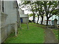
St John the Baptist, Fortuneswell: churchyard (2)
Image: © Basher Eyre
Taken: 4 Sep 2012
0.01 miles
7
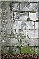
Benchmark on St John the Baptist Church, Fortuneswell
Ordnance Survey cut mark benchmark described on the Bench Mark Database at http://www.bench-marks.org.uk/bm40273
Image: © Roger Templeman
Taken: 21 Nov 2011
0.01 miles
8
St John the Baptist Church, Fortuneswell
There is an OS benchmark Image on the side of the church.
Image: © Roger Templeman
Taken: 21 Nov 2011
0.01 miles
9
Fortuneswell, St. John's
Victorian Anglican church on Fortuneswell: http://portlandparish.weebly.com/find-us.html
Image: © Mike Faherty
Taken: 24 Jan 2015
0.02 miles
10
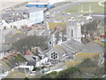
![Portland and Chesil Beach [5]](https://s3.geograph.org.uk/geophotos/06/78/29/6782995_beee2e18_120x120.jpg)
Portland and Chesil Beach [5]
This view from near the Olympic Rings Image looks over Fortuneswell towards Portland Harbour. The tower of the church of St John is prominent.
The Isle of Portland is a tied island, some 5 miles south of the resort of Weymouth, the southernmost point of the county of Dorset, joined to the mainland by Chesil Beach. The Isle has been inhabited since at least the Mesolithic period. Portland stone, a limestone famous for its use in world architecture is quarried here. Portland Harbour, is one of the largest man-made harbours in the world. Chesil Beach, a barrier beach, runs for 18 miles from West Bay to the Isle of Portland and in places is 50 feet high and 650 feet wide.
Image: © Michael Dibb
Taken: 11 Dec 2020
0.02 miles